1900s (20th Century) Maps of The Villas at Summerfield, Bowling Green
Explore 11 historic maps of The Villas at Summerfield from the 1900s (20th Century). These maps offer a rare glimpse into what life looked like during the 1900s — showing old roads, neighborhoods, homes, and landmarks that have changed or disappeared over time.
Whether you're researching your family's past, planning a metal detecting trip, or studying how The Villas at Summerfield's landscape evolved across the 1900s, these high-resolution maps are a powerful tool for exploring the history of this region.
- Focus on a specific era: All maps on this page are from the 1900s, giving you a focused view of this time period.
- See what’s changed: Compare century-old streets, trails, and buildings to today's modern landscape using overlays and satellite layers.
- Research with precision: Use these maps for genealogy, historical research, land use analysis, or educational projects.
- View, download, or print: Maps are fully viewable online in high resolution, and can be downloaded or printed for your own records.
Start exploring The Villas at Summerfield's history through authentic maps from the 1900s. This is your window into the past.
The Villas at Summerfield, Bowling Green maps
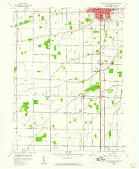
(11)- 1901 Map of Bowling Green, 1958 Print
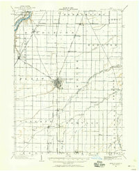 1901 Bowling Green1958 Print · USGSWood County at the turn of the century is a hub of steam and rail traffic centered on the growing seat of Bowling Green. Researchers can trace old family sites and rural settlements like Hull Prairie, Tontogany, and Jerry City across a landscape of early railroad lines.
 - 1903 Map of Bowling Green
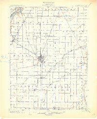 1903 Bowling Green1903 Print · USGSWood County at the turn of the century is a dense web of steam railroads and electric interurban lines connecting agricultural hubs. Researchers can trace the path of the Miami and Erie Canal or locate small settlements like Sugar Ridge, Tontogany, and Jerry City.3 unique versions available
 - 1938 Map of Tontogany
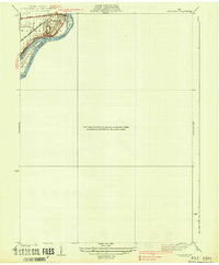 1938 Tontogany1938 Print · USGSThe Maumee River corridor in the late thirties is captured here at a major rail and road junction. Local historians can trace the early industrial footprint of Waterville and the Waterville Quarry, or locate river landmarks like Roche de Boeuf.2 unique versions available
 - 1952 Map of Tontogany, 1953 Print
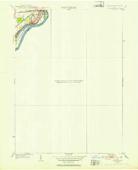 1952 Tontogany1953 Print · USGSThe riverfront town of Waterville is captured here in the early fifties, situated along a prominent stretch of the Maumee. Local historians can trace the paths of the New York Chicago and St Louis railroad and landmarks like Roche de Boeuf and Missionary Island.
 - 1956 Map of Toledo, 1968 Print
 1956 Toledo1968 Print · USGSNorthwest Ohio and the Lake Erie shoreline are shown in detail during the late fifties, showcasing a landscape of heavy industry, railroads, and island communities. Genealogists and historians can trace rail networks like the Chesapeake & Ohio RR or locate landmarks such as the Erie Proving Ground and Kelleys Island.4 unique versions available
 - 1958 Map of Bowling Green South, 1960 Print
 1958 Bowling Green South1960 Print · USGSWood County south of Bowling Green was a landscape of fertile plains and busy rail lines in the late fifties. Genealogists and local historians can trace the foundations of Digby, Rudolph, and Mermill, or locate family sites near Wingston Cemetery and Mt Zion Ch.2 unique versions available
 - 1958 Map of Bowling Green North, 1960 Print
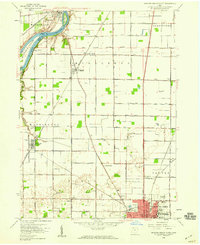 1958 Bowling Green North1960 Print · USGSWood County in the late fifties shows a landscape of river-bend settlements and expanding academic grounds. Researchers can trace the mid-century footprint of Bowling Green State University or locate family sites near Tontogany Cem and Haskins.6 unique versions available
 - 1961 Map of Toledo
 1961 Toledo1961 Print · USGSThe western basin of Lake Erie and the industrial heart of Northern Ohio are captured here during the post-war era. Researchers can trace historical rail lines like the New York Central or locate landmarks like the Erie Ordnance Depot and Pelee Island.
 - 1986 Map of Findlay
 1986 Findlay1986 Print · USGSNorthwest Ohio's industrial and agricultural heartland is documented here in the mid-1980s, centered on the major hubs of Findlay, Fostoria, and Tiffin. Researchers can trace the intersections of the BALTIMORE AND OHIO railroad and family sites near Greenlawn Cem or Sagar Ridge.2 unique versions available
 - 1994 Map of Bowling Green South, 1998 Print
 1994 Bowling Green South1998 Print · USGSWood County's agricultural heartland is documented here in the mid-1990s as the suburbs of Bowling Green expanded southward. Genealogists and local historians can trace family-named landmarks like Sargeant Cem and old crossroads hamlets such as Rudolph, Mermill, and Portage.
 - 1994 Map of Bowling Green North, 1998 Print
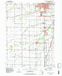
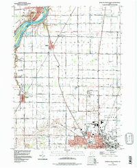 1994 Bowling Green North1998 Print · USGSThe Maumee River and the expanding campus of Bowling Green define this Wood County landscape in the mid-1990s. Genealogists can trace family names through the Union Hill Cem and Miltonville Cem or locate the old Plain Ch among the structured farmlands.
End of results
Showing maps 1-11 of 11
Frequently asked questions
- What are the different types of historical maps available for The Villas at Summerfield?
- What is the oldest map of The Villas at Summerfield?
- Where can I purchase historical maps of The Villas at Summerfield for my home or office?
- Where can I download high-res historical maps of The Villas at Summerfield?
- Are there historical topographic maps available for The Villas at Summerfield?
- Is there historical aerial imagery available for The Villas at Summerfield?
- Where are historical maps of The Villas at Summerfield sourced from?