1900-1909 Maps of Wyandot County, Ohio
Explore 6 historic maps of Wyandot County from 1900-1909. These maps offer a rare glimpse into what life looked like during the 1900s — showing old roads, neighborhoods, homes, and landmarks that have changed or disappeared over time.
Whether you're researching your family's past, planning a metal detecting trip, or studying how Wyandot County's landscape evolved across the 1900s, these high-resolution maps are a powerful tool for exploring the history of this region.
- Focus on a specific era: All maps on this page are from the 1900s, giving you a focused view of this time period.
- See what’s changed: Compare century-old streets, trails, and buildings to today's modern landscape using overlays and satellite layers.
- Research with precision: Use these maps for genealogy, historical research, land use analysis, or educational projects.
- View, download, or print: Maps are fully viewable online in high resolution, and can be downloaded or printed for your own records.
Start exploring Wyandot County's history through authentic maps from the 1900s. This is your window into the past.
Wyandot County, OH maps
(6)- 1903 Map of Marion, 1961 Print
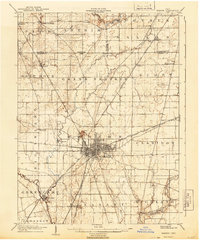
 1903 Marion1961 Print · USGSMarion emerges as a powerful rail hub at the turn of the century, with nearly ten different lines intersecting at the city's heart. Local historians can trace the early industrial landscape through the Electric RR and the Quarry near Owen.
 - 1905 Map of Marion, 1944 Print
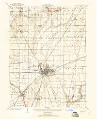
 1905 Marion1944 Print · USGSMarion became a bustling railroad crossroads at the turn of the century, serving as a vital link for the state's industrial and agricultural transport. Researchers can trace the early city grid, the path of the Hocking Valley Line, and rural outposts like Morral and Little Sandusky.
 - 1905 Map of Arlington, 1961 Print
 1905 Arlington1961 Print · USGSNorthwest Ohio at the turn of the century was a landscape of dense rail junctions and drainage-fed farmlands. You can trace the intersecting lines of the Northern Ohio RR and Ohio Central Lines at Arlington, or locate rural landmarks like Mt Moriah Church and the Treece School.
 - 1906 Map of Sycamore, 1932 Print
 1906 Sycamore1932 Print · USGSThe rural heart of north-central Ohio is captured here at the height of its steam-rail era. Genealogists and local historians can trace family locations near Sycamore, Nevada, and Belle Vernon, or locate landmarks like Oakgrove School and the Rock Run Church.
 - 1907 Map of Arlington
 1907 Arlington1907 Print · USGSNorthwestern Ohio's fertile landscape is captured here during the peak of its rail-and-river economy. Genealogists can trace family roots through local landmarks like North Washington PO, Jones School, and the Mt Olivet Church.2 unique versions available
 - 1907 Map of Upper Sandusky, 1943 Print
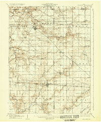
 1907 Upper Sandusky1943 Print · USGSWyandot County at the dawn of the twentieth century was a landscape of thriving rail junctions and dispersed rural school districts. Genealogists and local historians can trace the exact locations of family landmarks like Grace Chapel, the Indian Mill, and numerous rural schools from Moody School to Hendricks School 24.
End of results
Showing maps 1-6 of 6
Top cities of Wyandot County
Frequently asked questions
- What are the different types of historical maps available for Wyandot County?
- What is the oldest map of Wyandot County?
- Where can I purchase historical maps of Wyandot County for my home or office?
- Where can I download high-res historical maps of Wyandot County?
- Are there historical topographic maps available for Wyandot County?
- Is there historical aerial imagery available for Wyandot County?
- Where are historical maps of Wyandot County sourced from?