1970s Maps of Adair County, Oklahoma
Explore 19 historic maps of Adair County from the 1970s. These maps offer a rare glimpse into what life looked like during the 1970s — showing old roads, neighborhoods, homes, and landmarks that have changed or disappeared over time.
Whether you're researching your family's past, planning a metal detecting trip, or studying how Adair County's landscape evolved across the 1970s, these high-resolution maps are a powerful tool for exploring the history of this region.
- Focus on a specific era: All maps on this page are from the 1970s, giving you a focused view of this time period.
- See what’s changed: Compare century-old streets, trails, and buildings to today's modern landscape using overlays and satellite layers.
- Research with precision: Use these maps for genealogy, historical research, land use analysis, or educational projects.
- View, download, or print: Maps are fully viewable online in high resolution, and can be downloaded or printed for your own records.
Start exploring Adair County's history through authentic maps from the 1970s. This is your window into the past.
Adair County, OK maps
(19)- 1970 Map of Evansville, 1972 Print
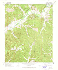
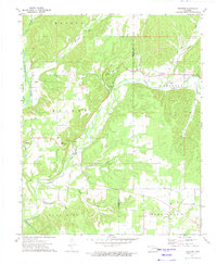
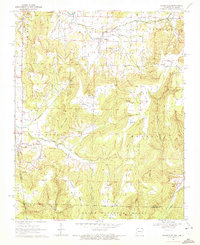 1970 Evansville1972 Print · USGSSettled valleys and mountain ridges define the Arkansas-Oklahoma border during the early seventies. Genealogists can trace family roots through numerous burial sites like Vineyard Cem, Goddard Cem, and the community of Dutch Mills.3 unique versions available
 - 1972 Map of Chance, 1974 Print
 1972 Chance1974 Print · USGSAdair County in the early 1970s shows a landscape of tucked-away hollows and rural congregations. Genealogists and local historians can trace family locations near New Hope Cem, the settlement of Chance, and the northern outskirts of Westville.
 - 1972 Map of Kansas, 1974 Print
 1972 Kansas1974 Print · USGSNortheastern Oklahoma at the edge of the Cookson Hills reveals a landscape of tight-knit valley communities in the early 1970s. Trace local family history through landmarks like Walnut Grove Mission, the Oaks Cem, and the winding waters of Black Fox Springs.
 - 1972 Map of Christie, 1974 Print
 1972 Christie1974 Print · USGSAdair County's rural landscape is captured here in the early seventies, centered on the Baron Fork and the timbered heights of Spade Mountain. Genealogists can locate family landmarks like Walkingstick Cem and the West Peavine Sch.
 - 1972 Map of Chewey, 1974 Print
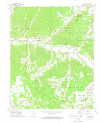
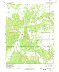
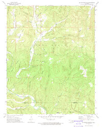
 1972 Chewey1974 Print · USGSThe Illinois River valley in the early 1970s reveals a secluded landscape of deep hollows and river bends along the Adair and Cherokee county line. Researchers can trace rural landmarks like Thompson Cem, the Hampton Bridge, and the small settlement of Chewey.
 - 1972 Map of Watts, 1974 Print
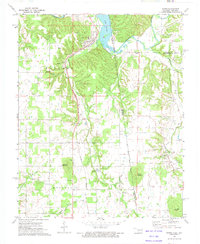 1972 Watts1974 Print · USGSThe Arkansas-Oklahoma borderlands come alive in the early seventies as the rail line connects rural outposts. Trace family roots at Sixkiller Cem or explore the waters of Lake Frances and the ridges of Mission Mountain.2 unique versions available
 - 1972 Map of Siloam Springs NW, 1974 Print
 1972 Siloam Springs NW1974 Print · USGSThe Illinois River valley on the Delaware-Adair county line is shown here in the early 1970s. Researchers can trace rural landmarks like Crittenden Cem, the community of Flint, and the Moseley Sch across the prairie.2 unique versions available
 - 1972 Map of Stilwell West, 1974 Print
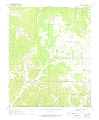
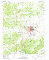
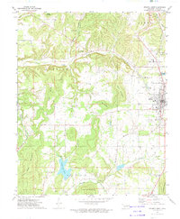 1972 Stilwell West1974 Print · USGSAdair County in the early seventies shows the growing community of Stilwell anchored by the Kansas City Southern railroad and several prominent peaks. Genealogists can trace family names and local history through rural landmarks like Maryetta Sch, Zion Ch, and Stony Point.
 - 1972 Map of Siloam Springs, 1974 Print
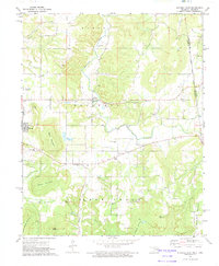
 1972 Siloam Springs1974 Print · USGSSiloam Springs and its rural neighbors are caught in a period of steady growth during the early seventies along the state line. Genealogists and historians can trace family plots at Oak Hill Cemetery or Bell Cem, and locate the historic campus of John Brown University.2 unique versions available
 - 1972 Map of Tailholt, 1974 Print
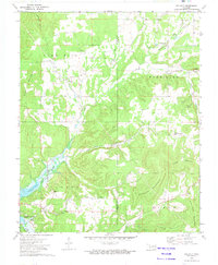 1972 Tailholt1974 Print · USGSCherokee County in the early seventies shows the rural life of the Cookson Hills as the waters of Tenkiller Ferry Lake reached their modern levels. Researchers can trace historic local sites like Tailholt, the Tenkiller Sch, and several remote family burial grounds including Stony Point Cem.2 unique versions available
 - 1972 Map of Westville, 1974 Print
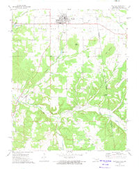 1972 Westville1974 Print · USGSAdair County and the Oklahoma-Arkansas border are documented here in the early 1970s, centered on the rail hub of Westville. Genealogists and historians can trace family burial sites like Alberty Cem or locate the historic Indian Treaty Boundary and the tracks of the Kansas City Southern.
 - 1972 Map of Bunch, 1974 Print
 1972 Bunch1974 Print · USGSThe Cookson Hills of eastern Oklahoma are captured here in the early seventies, spanning the borders of Adair and Cherokee counties. Researchers can locate the mountain village of Bunch, follow the Kansas City Southern rail line, or trace family sites like Cave Springs Ch and Henderson Cem.
 - 1972 Map of Proctor, 1974 Print
 1972 Proctor1974 Print · USGSAdair and Cherokee Counties are captured in the early seventies, showing a landscape of river valleys and rugged foothills. Genealogists can trace family names and local sites like Oakdale Church, the community of Titanic, and the Old Railroad Grade near Eldon.2 unique versions available
 - 1972 Map of Stilwell East, 1974 Print
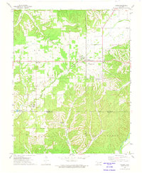
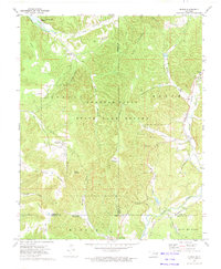
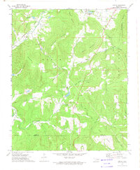
 1972 Stilwell East1974 Print · USGSAdair County, Oklahoma, comes into focus in the early 1970s, where the Ozark foothills meet the Arkansas border. Genealogists and historians can trace the OLD INDIAN TREATY BOUNDARY and locate many rural landmarks like Fourkiller Cem and Rock Springs Ch.
 - 1973 Map of Big Round Mountain, 1974 Print
 1973 Big Round Mountain1974 Print · USGSThe Adair County highlands are captured here in the early 1970s, showing a landscape of traditional upland settlements and deep hollows. Genealogists can trace family landmarks like John Watie Hollow or locate local centers like Salem Ch and Bell Sch.3 unique versions available
 - 1973 Map of Greasy, 1974 Print
 1973 Greasy1974 Print · USGSThe hill country of eastern Oklahoma in the early seventies shows a landscape of secluded hollows and family-named ridges. Genealogists and historians can trace local landmarks like Cherry Tree, the Kansas City Southern railroad, and rural cemeteries including Killer Cem and Chuliawa Cem.2 unique versions available
 - 1978 Map of Fort Smith, 1979 Print
 1978 Fort Smith1979 Print · USGSThe Arkansas-Oklahoma borderlands in the late seventies show a landscape shaped by massive river reservoirs and sprawling military reservations. Trace the historic rail lines of the Missouri Pacific RR and locate regional landmarks like Fort Gibson, Tenkiller Ferry Lake, and Barling.2 unique versions available
 - 1978 Map of Stilwell, 1979 Print
 1978 Stilwell1979 Print · USGSThe Oklahoma-Arkansas borderlands come alive in the late seventies, showing the transition from the Cherokee Nation hills to the Arkansas Ozarks. Researchers can trace the Kansas City Southern rail line through Stilwell, find Wrights Chapel, or locate the Northeastern State College campus in Tahlequah.
 - 1979 Map of Fayetteville, 1980 Print
 1979 Fayetteville1980 Print · USGSNorthwest Arkansas and the tristate corner show a booming corridor of rail-linked towns and highland forests in the late seventies. Researchers can trace historic landmarks like Pea Ridge National Military Park, the Frisco RR, and the University of Arkansas.2 unique versions available
End of results
Showing maps 1-19 of 19
Top cities of Adair County
Frequently asked questions
- What are the different types of historical maps available for Adair County?
- What is the oldest map of Adair County?
- Where can I purchase historical maps of Adair County for my home or office?
- Where can I download high-res historical maps of Adair County?
- Are there historical topographic maps available for Adair County?
- Is there historical aerial imagery available for Adair County?
- Where are historical maps of Adair County sourced from?