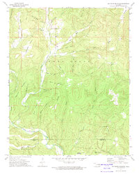
1973 Map of Big Round Mountain
USGS Topo · Published 1974About this map
Bell is the central settlement in this upland portion of the Cookson Hills, appearing here in the early 1970s. The landscape is defined by the sharp transition between the Ozark Plateau's timbered ridges and its deeply incised drainages, including the winding course of Little Lee Creek. Local social life is anchored by the Salem Ch and Bell Sch, with further rural education formerly centered at the Oak Ridge Sch near the Arkansas border. The terrain is a network of named hollows and peaks, many bearing family names like Vanderheiden Mountain and John Watie Hollow, reflecting the deep-rooted Cherokee heritage of this corner of the state. Atop Big Round Mtn, a Lookout Tower stands as a sentinel over the complex topography of Hunt Mill Hollow and the Adair Co and Sequoyah Co line.
Find a feature on this map
38 named features on this map. Tap any name to fly to it.
Don’t see what you’re looking for? This feature index may not catch every label — zoom into the map to look around manually.
Map Details
Editions of this 1973 Big Round Mountain Map
3 editions found
Other maps of this area

1898 · Winslow #3
USGS Topo · 1:62,500

1898 · Tahlequah
USGS Topo · 1:125,000

1898 · Winslow
USGS Topo · 1:125,000

1901 · Winslow
USGS Topo · 1:125,000

1901 · Tahlequah
USGS Topo · 1:125,000

1905 · Tahlequah
USGS Topo · 1:125,000

1946 · Fort Smith
USGS Topo · 1:250,000

1965 · Fort Smith
USGS Topo · 1:250,000

1967 · Fort Smith
USGS Topo · 1:250,000
1969 · Uniontown
USGS Topo · 1:24,000