
1901 Map of Winslow
USGS Topo · Published 1901About this map
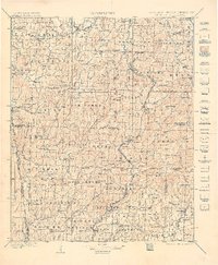
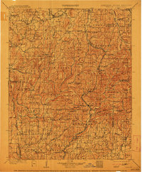
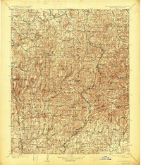
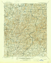
Winslow sits high atop the Boston Mountains on this 1898 survey, serving as a critical point where the St. Louis and San Francisco R. R. traverses the divide between the White River and Frog Bayou watersheds. The map documents a landscape of high ridges and deep hollows at the boundary of Arkansas and the Indian Territory, including the Cherokee Nation line. The historic Old Wire Road snakes through the central corridor, passing through settlements like Brentwood and Woolsey. To the northwest, the terrain opens into the agricultural lands of Prairie Grove and Cane Hill, where long-established communities like Rheas Mill and Dutch Mills are situated. Numerous family-named summits like Stevenson Mt. and Lockard Mt. define the skyline, while the network of creeks like Lee Creek and Cove Creek illustrates the complex drainage patterns that challenged early rail and road engineering in this upland region.
Find a feature on this map
186 named features on this map. Tap any name to fly to it.
Don’t see what you’re looking for? This feature index may not catch every label — zoom into the map to look around manually.
Map Details
Editions of this 1901 Winslow Map
5 editions found
Other maps of this area

1879 · Cravens
USGS Topo · 1:62,500

1879 · Fort Smith
USGS Topo · 1:62,500

1887 · Van Buren
USGS Topo · 1:62,500

1887 · Magazine Mountain #2
USGS Topo · 1:62,500

1887 · Watalula
USGS Topo · 1:62,500

1887 · Magazine Mountain
USGS Topo · 1:62,500

1890 · Magazine Mountain
USGS Topo · 1:125,000

1890 · Fort Smith
USGS Topo · 1:125,000

1898 · Winslow #4
USGS Topo · 1:62,500

1898 · Winslow #3
USGS Topo · 1:62,500