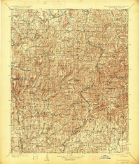
1901 Map of Winslow
USGS Topo · Published 1927About this map
St Louis and San Francisco RR tracks bisect this rugged section of the Boston Mountains, following the precarious divide between the White River and Frog Bayou watersheds. Surveyed in the late 19th century, the map documents a transition from the agricultural plateaus of Prairie Grove and Lincoln into the steep, timbered ridges of the Ozark National Forest. Notable landmarks such as the Natural Dam on Lee Creek and the high summit of Skylight Mtn define the landscape, while the Old Wire Road traces an essential overland corridor through the hills. Small rural settlements like Dutch Mills, Cove City, and Evansville are shown before modern highway development, alongside many family-named peaks including Bloyd Mtn and Stevenson Mtn that characterize the complex topography of Washington and Crawford Counties.
Find a feature on this map
99 named features on this map. Tap any name to fly to it.
Don’t see what you’re looking for? This feature index may not catch every label — zoom into the map to look around manually.
Map Details
Editions of this 1901 Winslow Map
5 editions found

Other maps of this area

1879 · Cravens
USGS Topo · 1:62,500

1879 · Fort Smith
USGS Topo · 1:62,500

1887 · Van Buren
USGS Topo · 1:62,500

1887 · Magazine Mountain #2
USGS Topo · 1:62,500

1887 · Watalula
USGS Topo · 1:62,500

1887 · Magazine Mountain
USGS Topo · 1:62,500

1890 · Magazine Mountain
USGS Topo · 1:125,000

1890 · Fort Smith
USGS Topo · 1:125,000

1898 · Winslow #4
USGS Topo · 1:62,500

1898 · Winslow #3
USGS Topo · 1:62,500