1900s (20th Century) Maps of Texola, Oklahoma
Explore 9 historic maps of Texola from the 1900s (20th Century). These maps offer a rare glimpse into what life looked like during the 1900s — showing old roads, neighborhoods, homes, and landmarks that have changed or disappeared over time.
Whether you're researching your family's past, planning a metal detecting trip, or studying how Texola's landscape evolved across the 1900s, these high-resolution maps are a powerful tool for exploring the history of this region.
- Focus on a specific era: All maps on this page are from the 1900s, giving you a focused view of this time period.
- See what’s changed: Compare century-old streets, trails, and buildings to today's modern landscape using overlays and satellite layers.
- Research with precision: Use these maps for genealogy, historical research, land use analysis, or educational projects.
- View, download, or print: Maps are fully viewable online in high resolution, and can be downloaded or printed for your own records.
Start exploring Texola's history through authentic maps from the 1900s. This is your window into the past.
Texola, OK maps
(9)- 1954 Map of Amarillo, 1966 Print
 1954 Amarillo1966 Print · USGSThe Texas Panhandle in the mid-1960s shows a landscape of rising industrial power and deep-rooted ranching tradition. Local historians can trace the paths of the Panhandle and Santa Fe railroad or locate sites like the Pantex Ordnance Plant and Mobeetie.2 unique versions available
 - 1955 Map of Clinton, 1964 Print
 1955 Clinton1964 Print · USGSWestern Oklahoma during the mid-century transition shows a landscape of growing reservoirs and active military flight lines. Genealogists and historians can locate rural landmarks such as Mountain View Church, Berlin School, and the Riverside Indian School Reserve.3 unique versions available
 - 1957 Map of Clinton
 1957 Clinton1957 Print · USGSWestern Oklahoma in the mid-fifties is captured here as a landscape of river-valley settlements and emerging energy fields. Genealogists can trace family roots through numerous rural landmarks like the Swapping Back Indian School, Hebron Church, and the Riverside Indian School Reserve.
 - 1958 Map of Amarillo
 1958 Amarillo1958 Print · USGSThe Texas Panhandle in the mid-1950s reveals a landscape of expanding military installations and oil-rich rail towns. Local historians can trace the development of Amarillo Air Force Base or locate smaller settlements like Magic City and New Mobeetie.
 - 1961 Map of Erick, 1963 Print
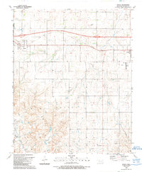
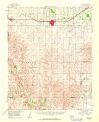 1961 Erick1963 Print · USGSBeckham County, Oklahoma, sits at the intersection of the Texas border and the great rail lines during the early 1960s. Family historians can trace the community life of Erick and Texola, finding specific landmarks like Munnerson Cem and the local Drive-in Theater.2 unique versions available
 - 1963 Map of Fulller, 1967 Print
 1963 Fulller1967 Print · USGSWheeler County and the Oklahoma borderlands are captured here in the early sixties, showing the rail and road network of the High Plains. Researchers can trace the Chicago Rock Island and Pacific railroad through Fuller or locate early energy infrastructure like a regional Pipeline.
 - 1983 Map of Shamrock
 1983 Shamrock1983 Print · USGSThe Texas Panhandle in the early 1980s reveals a landscape shaped by petroleum and the rail lines of the southern plains. Genealogists and historians can trace the Chicago Rock Island and Pacific corridor through Mc Lean and Shamrock, or locate smaller centers like Magic City and Lefors.
 - 1985 Map of Elk City
 1985 Elk City1985 Print · USGSWestern Oklahoma in the 1980s is defined by its railroad junctions, emerging aviation hubs, and the winding North Fork Red River. Genealogists and local historians can trace the foundations of Sayre and Elk City, alongside landmarks like Clinton-Sherman Airport and Quartz Mountain State Park.2 unique versions available
 - 1989 Map of Texola
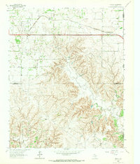
 1989 Texola1989 Print · USGSThe Oklahoma-Texas borderlands are captured here in the late twentieth century, centered on the cross-border community of Texola. Genealogists and local historians can trace the Old Railroad Grade and find sites like Texola Cem, Davis Cem, and Haddock Airport.
End of results
Showing maps 1-9 of 9
Top cities near Texola
Frequently asked questions
- What are the different types of historical maps available for Texola?
- What is the oldest map of Texola?
- Where can I purchase historical maps of Texola for my home or office?
- Where can I download high-res historical maps of Texola?
- Are there historical topographic maps available for Texola?
- Is there historical aerial imagery available for Texola?
- Where are historical maps of Texola sourced from?