1900s (20th Century) Maps of Alden, Oklahoma
Explore 6 historic maps of Alden from the 1900s (20th Century). These maps offer a rare glimpse into what life looked like during the 1900s — showing old roads, neighborhoods, homes, and landmarks that have changed or disappeared over time.
Whether you're researching your family's past, planning a metal detecting trip, or studying how Alden's landscape evolved across the 1900s, these high-resolution maps are a powerful tool for exploring the history of this region.
- Focus on a specific era: All maps on this page are from the 1900s, giving you a focused view of this time period.
- See what’s changed: Compare century-old streets, trails, and buildings to today's modern landscape using overlays and satellite layers.
- Research with precision: Use these maps for genealogy, historical research, land use analysis, or educational projects.
- View, download, or print: Maps are fully viewable online in high resolution, and can be downloaded or printed for your own records.
Start exploring Alden's history through authentic maps from the 1900s. This is your window into the past.
Alden, OK maps
(6)- 1950 Map of Saddle Mountain, 1953 Print
 1950 Saddle Mountain1953 Print · USGSSouthwestern Oklahoma in the early fifties shows a landscape where high granite peaks meet missionary history and early wildlife conservation. Researchers can trace rural school locations like Dixie Sch or find the remote Saddle Mountain Indian Mission and Kiowa Mission tucked among the foothills.2 unique versions available
 - 1955 Map of Lawton, 1958 Print
 1955 Lawton1958 Print · USGSSouthwestern Oklahoma and North Texas are shown here in the mid-fifties, dominated by the Wichita Mountains and the vital Red River watershed. Genealogists and historians can trace the foundations of Lawton alongside rural landmarks like Rainy Mountain Church and Pleasant Hill School.5 unique versions available
 - 1956 Map of Alden, 1959 Print
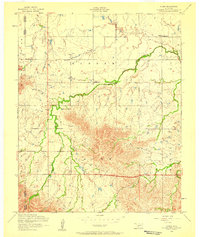 1956 Alden1959 Print · USGSCaddo County's agricultural prairies meet the rising slopes of the Wichita Mountains during the mid-fifties. Researchers can locate family landmarks like the Alden School, Cache Indian Mission, and the Greenfield Church near East Cache Creek.2 unique versions available
 - 1956 Map of Saddle Mountain, 1960 Print
 1956 Saddle Mountain1960 Print · USGSThe Wichita Mountains and surrounding plains are captured in the mid-fifties, featuring the Wichita Mountains Wildlife Refuge and its dramatic peaks. Genealogy researchers can trace community roots at the Cache Indian Mission, Alden School, and Meers Cemetery.
 - 1981 Map of Lawton
 1981 Lawton1981 Print · USGSSouthwestern Oklahoma in the early eighties shows a landscape shaped by military history and the rising peaks of the Wichitas. Researchers can trace the boundaries of the Fort Sill Military Reservation and locate early settlements like Meers, Chattanooga, and Richards Spur.
 - 1991 Map of Alden, 1992 Print
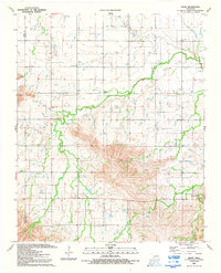 1991 Alden1992 Print · USGSCaddo County in the early nineties shows a landscape of active oil production and established rural faith communities. Researchers can trace the layout of the Oil Field and find family landmarks like Greenfield Ch, Cache Indian Mission, and Camp George Thomas.
End of results
Showing maps 1-6 of 6
Top cities near Alden
- Carnegie historical maps
- Apache historical maps
- Mountain View historical maps
- Fort Cobb historical maps
Frequently asked questions
- What are the different types of historical maps available for Alden?
- What is the oldest map of Alden?
- Where can I purchase historical maps of Alden for my home or office?
- Where can I download high-res historical maps of Alden?
- Are there historical topographic maps available for Alden?
- Is there historical aerial imagery available for Alden?
- Where are historical maps of Alden sourced from?