1970s Maps of Gracemont, Oklahoma
Explore 1 historic maps of Gracemont from the 1970s. These maps offer a rare glimpse into what life looked like during the 1970s — showing old roads, neighborhoods, homes, and landmarks that have changed or disappeared over time.
Whether you're researching your family's past, planning a metal detecting trip, or studying how Gracemont's landscape evolved across the 1970s, these high-resolution maps are a powerful tool for exploring the history of this region.
- Focus on a specific era: All maps on this page are from the 1970s, giving you a focused view of this time period.
- See what’s changed: Compare century-old streets, trails, and buildings to today's modern landscape using overlays and satellite layers.
- Research with precision: Use these maps for genealogy, historical research, land use analysis, or educational projects.
- View, download, or print: Maps are fully viewable online in high resolution, and can be downloaded or printed for your own records.
Start exploring Gracemont's history through authentic maps from the 1970s. This is your window into the past.
Gracemont, OK maps
(1)- 1979 Map of Gracemont
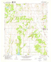 1979 Gracemont1979 Print · USGSGracemont and the surrounding Caddo County prairie are captured here in the late seventies, showing a landscape defined by deep-cut canyons and vital creek networks. Researchers can locate the Gracemont Cem, trace the waters of Stockton Canyon, or find family-named landmarks like Keechi Creek and Public Service Reservoir No 3.2 unique versions available
End of results
Showing maps 1-1 of 1
Top cities near Gracemont
- Anadarko historical maps
- Verden historical maps
- Fort Cobb historical maps
- Binger historical maps
- Lookeba historical maps
Frequently asked questions
- What are the different types of historical maps available for Gracemont?
- What is the oldest map of Gracemont?
- Where can I purchase historical maps of Gracemont for my home or office?
- Where can I download high-res historical maps of Gracemont?
- Are there historical topographic maps available for Gracemont?
- Is there historical aerial imagery available for Gracemont?
- Where are historical maps of Gracemont sourced from?