1970s Maps of Hinton, Oklahoma
Explore 3 historic maps of Hinton from the 1970s. These maps offer a rare glimpse into what life looked like during the 1970s — showing old roads, neighborhoods, homes, and landmarks that have changed or disappeared over time.
Whether you're researching your family's past, planning a metal detecting trip, or studying how Hinton's landscape evolved across the 1970s, these high-resolution maps are a powerful tool for exploring the history of this region.
- Focus on a specific era: All maps on this page are from the 1970s, giving you a focused view of this time period.
- See what’s changed: Compare century-old streets, trails, and buildings to today's modern landscape using overlays and satellite layers.
- Research with precision: Use these maps for genealogy, historical research, land use analysis, or educational projects.
- View, download, or print: Maps are fully viewable online in high resolution, and can be downloaded or printed for your own records.
Start exploring Hinton's history through authentic maps from the 1970s. This is your window into the past.
Hinton, OK maps
(3)- 1979 Map of Hinton
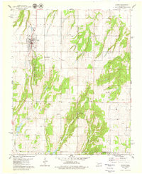 1979 Hinton1979 Print · USGSHinton and the surrounding Caddo County landscape are captured here in the late seventies as the town centered itself around the canyon systems. Researchers can trace ancestral sites at Hinton Cem and Sacred Heart Cem or locate the Old Railroad Grade.
 - 1979 Map of Geary South
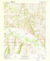 1979 Geary South1979 Print · USGSThe Canadian River valley in the late seventies reveals a landscape shaped by rail, river, and rural industry. Researchers can trace the Chicago Rock Island and Pacific rail lines, the Old Railroad Grade, and local sites like Graceland Cem and Hinton Junction.2 unique versions available
 - 1979 Map of Rock Mary
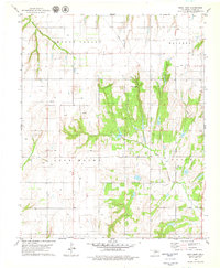 1979 Rock Mary1979 Print · USGSCaddo County's agricultural and energy landscape comes into focus during the late seventies, showing the rural communities of Sickles and Ferns. You can trace the rugged topography of Rock Mary and locate historic local landmarks like the Cedar Valley Ch.2 unique versions available
End of results
Showing maps 1-3 of 3
Top cities near Hinton
- Geary historical maps
- Calumet historical maps
- Binger historical maps
- Eakly historical maps
- Bridgeport historical maps
- Lookeba historical maps
Frequently asked questions
- What are the different types of historical maps available for Hinton?
- What is the oldest map of Hinton?
- Where can I purchase historical maps of Hinton for my home or office?
- Where can I download high-res historical maps of Hinton?
- Are there historical topographic maps available for Hinton?
- Is there historical aerial imagery available for Hinton?
- Where are historical maps of Hinton sourced from?