1940s Maps of Grant, Oklahoma
Explore 2 historic maps of Grant from the 1940s. These maps offer a rare glimpse into what life looked like during the 1940s — showing old roads, neighborhoods, homes, and landmarks that have changed or disappeared over time.
Whether you're researching your family's past, planning a metal detecting trip, or studying how Grant's landscape evolved across the 1940s, these high-resolution maps are a powerful tool for exploring the history of this region.
- Focus on a specific era: All maps on this page are from the 1940s, giving you a focused view of this time period.
- See what’s changed: Compare century-old streets, trails, and buildings to today's modern landscape using overlays and satellite layers.
- Research with precision: Use these maps for genealogy, historical research, land use analysis, or educational projects.
- View, download, or print: Maps are fully viewable online in high resolution, and can be downloaded or printed for your own records.
Start exploring Grant's history through authentic maps from the 1940s. This is your window into the past.
Grant, OK maps
(2)- 1948 Map of Grant, 1963 Print
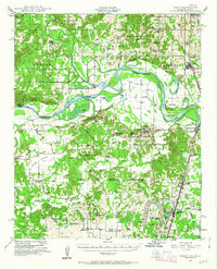 1948 Grant1963 Print · USGSThe Red River borderlands of Oklahoma and Texas are shown here in the late 1940s, featuring the extensive Camp Maxey Military Reservation. Researchers can trace the St Louis San Francisco Railway through Grant and locate dozens of local landmarks like Hills Chapel School and Goodland Cem.2 unique versions available
 - 1949 Map of Grant
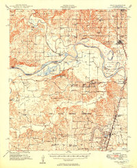 1949 Grant1949 Print · USGSThe Red River borderlands of Oklahoma and Texas are captured here just after the war, showing a rural landscape dominated by large river bends and military expansion. You can trace early community hubs like Grant and Arthur City or locate local landmarks like Hills Chapel School and Forest Chapel.2 unique versions available
End of results
Showing maps 1-2 of 2
Top cities near Grant
- Paris historical maps
- Hugo historical maps
- Fort Towson historical maps
- Sawyer historical maps
- Soper historical maps
Frequently asked questions
- What are the different types of historical maps available for Grant?
- What is the oldest map of Grant?
- Where can I purchase historical maps of Grant for my home or office?
- Where can I download high-res historical maps of Grant?
- Are there historical topographic maps available for Grant?
- Is there historical aerial imagery available for Grant?
- Where are historical maps of Grant sourced from?