1990s Maps of Cleveland County, Oklahoma
Explore 4 historic maps of Cleveland County from the 1990s. These maps offer a rare glimpse into what life looked like during the 1990s — showing old roads, neighborhoods, homes, and landmarks that have changed or disappeared over time.
Whether you're researching your family's past, planning a metal detecting trip, or studying how Cleveland County's landscape evolved across the 1990s, these high-resolution maps are a powerful tool for exploring the history of this region.
- Focus on a specific era: All maps on this page are from the 1990s, giving you a focused view of this time period.
- See what’s changed: Compare century-old streets, trails, and buildings to today's modern landscape using overlays and satellite layers.
- Research with precision: Use these maps for genealogy, historical research, land use analysis, or educational projects.
- View, download, or print: Maps are fully viewable online in high resolution, and can be downloaded or printed for your own records.
Start exploring Cleveland County's history through authentic maps from the 1990s. This is your window into the past.
Cleveland County, OK maps
(4)- 1995 Map of Norman, 1999 Print
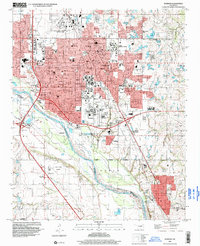 1995 Norman1999 Print · USGSNorman and the surrounding Cleveland County landscape are shown here during the mid-nineties as the city expanded around the University of Oklahoma. Researchers can trace the layout of historic campuses and local landmarks like the I O O F Cemetery, Westheimer Field, and the East Norman Oil Field.
 - 1995 Map of Oklahoma City, 2000 Print
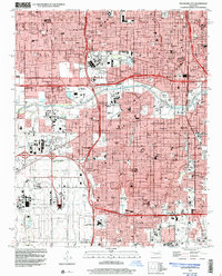 1995 Oklahoma City2000 Print · USGSOklahoma City in the mid-nineties shows a metropolis deeply integrated with its aviation and industrial hubs. Genealogists and historians can locate numerous neighborhood landmarks, from Czech Cemetery to schools like Capitol Hill High School.
 - 1995 Map of Midwest City, 2000 Print
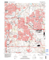 1995 Midwest City2000 Print · USGSMid-century urban expansion and military infrastructure define this Oklahoma County landscape in the mid-nineties. Researchers can locate family landmarks like Sunnylane Cemetery, the sprawling Tinker Air Force Base, and schools like Douglass High Sch.
 - 1995 Map of Moore, 2000 Print
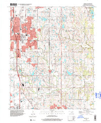 1995 Moore2000 Print · USGSThe growing corridors between Moore and Oklahoma City are captured here in the mid-nineties during a period of significant suburban expansion. Genealogists and local historians can locate early institutions like Smith Cem, Brookside Chapel, and the settlement of Hollywood Corners.
End of results
Showing maps 1-4 of 4
Top cities of Cleveland County
- Norman historical maps
- Moore historical maps
- Noble historical maps
- Slaughterville historical maps
- Lexington historical maps
- Etowah historical maps
Frequently asked questions
- What are the different types of historical maps available for Cleveland County?
- What is the oldest map of Cleveland County?
- Where can I purchase historical maps of Cleveland County for my home or office?
- Where can I download high-res historical maps of Cleveland County?
- Are there historical topographic maps available for Cleveland County?
- Is there historical aerial imagery available for Cleveland County?
- Where are historical maps of Cleveland County sourced from?