1900s (20th Century) Maps of Granite, Oklahoma
Explore 4 historic maps of Granite from the 1900s (20th Century). These maps offer a rare glimpse into what life looked like during the 1900s — showing old roads, neighborhoods, homes, and landmarks that have changed or disappeared over time.
Whether you're researching your family's past, planning a metal detecting trip, or studying how Granite's landscape evolved across the 1900s, these high-resolution maps are a powerful tool for exploring the history of this region.
- Focus on a specific era: All maps on this page are from the 1900s, giving you a focused view of this time period.
- See what’s changed: Compare century-old streets, trails, and buildings to today's modern landscape using overlays and satellite layers.
- Research with precision: Use these maps for genealogy, historical research, land use analysis, or educational projects.
- View, download, or print: Maps are fully viewable online in high resolution, and can be downloaded or printed for your own records.
Start exploring Granite's history through authentic maps from the 1900s. This is your window into the past.
Granite, OK maps
(4)- 1955 Map of Lawton, 1958 Print
 1955 Lawton1958 Print · USGSSouthwestern Oklahoma and North Texas are shown here in the mid-fifties, dominated by the Wichita Mountains and the vital Red River watershed. Genealogists and historians can trace the foundations of Lawton alongside rural landmarks like Rainy Mountain Church and Pleasant Hill School.5 unique versions available
 - 1971 Map of Granite, 1973 Print
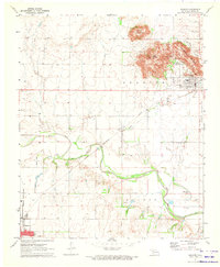 1971 Granite1973 Print · USGSGreer County at the start of the seventies features a landscape where the granite peaks of Walsh Mountain meet the Elm Fork Red River. Researchers can trace the massive State Reformatory complex, find Rock Cem, or follow the old Rock Island rail line.
 - 1971 Map of Lake Altus, 1973 Print
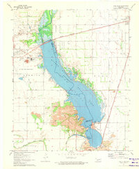 1971 Lake Altus1973 Print · USGSSouthwestern Oklahoma's landscape was defined by massive water projects and rugged granite peaks in the early 1970s. Trace the lakefront of Quartz Mountain Lake, the rails of the Atchison Topeka and Santa Fe, and the townsite of Lugert.
 - 1985 Map of Altus
 1985 Altus1985 Print · USGSSouthwestern Oklahoma in the mid-eighties shows a vast agricultural and military landscape shaped by the Red River forks. Trace the intersections of the Atchison Topeka and Santa Fe railroad with rural points like Fairmount Cem and Duke.2 unique versions available
End of results
Showing maps 1-4 of 4
Top cities near Granite
- Mangum historical maps
- Sentinel historical maps
- Blair historical maps
- Lone Wolf historical maps
- Willow historical maps
Top neighborhoods of Granite
- Bartlett historical maps
- Bartlett historical maps
- Bartlett historical maps
- Bartlett historical maps
- Broadie historical maps
- Cox Res Resv historical maps
See more
Frequently asked questions
- What are the different types of historical maps available for Granite?
- What is the oldest map of Granite?
- Where can I purchase historical maps of Granite for my home or office?
- Where can I download high-res historical maps of Granite?
- Are there historical topographic maps available for Granite?
- Is there historical aerial imagery available for Granite?
- Where are historical maps of Granite sourced from?