1970s Maps of Wetumka, Oklahoma
Explore 2 historic maps of Wetumka from the 1970s. These maps offer a rare glimpse into what life looked like during the 1970s — showing old roads, neighborhoods, homes, and landmarks that have changed or disappeared over time.
Whether you're researching your family's past, planning a metal detecting trip, or studying how Wetumka's landscape evolved across the 1970s, these high-resolution maps are a powerful tool for exploring the history of this region.
- Focus on a specific era: All maps on this page are from the 1970s, giving you a focused view of this time period.
- See what’s changed: Compare century-old streets, trails, and buildings to today's modern landscape using overlays and satellite layers.
- Research with precision: Use these maps for genealogy, historical research, land use analysis, or educational projects.
- View, download, or print: Maps are fully viewable online in high resolution, and can be downloaded or printed for your own records.
Start exploring Wetumka's history through authentic maps from the 1970s. This is your window into the past.
Wetumka, OK maps
(2)- 1971 Map of Wetumka, 1973 Print
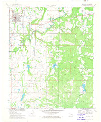 1971 Wetumka1973 Print · USGSWetumka and the surrounding Hughes County countryside are shown here in the early 1970s, characterized by a mix of rail transit and active energy extraction. Genealogists and local historians can locate family landmarks like Barnett Cem or trace the ST L-S F railroad.2 unique versions available
 - 1972 Map of Yeager, 1974 Print
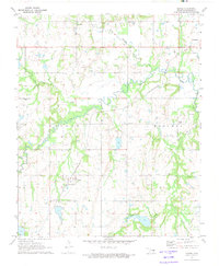 1972 Yeager1974 Print · USGSCentral Oklahoma's oil fields and rural townships are captured in the early seventies, centered on the community of Yeager. Genealogists and historians can trace family sites like Wisner Cem and several local churches along the St Louis-San Francisco rail line.
End of results
Showing maps 1-2 of 2
Top cities near Wetumka
- Holdenville historical maps
- Henryetta historical maps
- Okemah historical maps
- Weleetka historical maps
- Dustin historical maps
- Cromwell historical maps
See more
Frequently asked questions
- What are the different types of historical maps available for Wetumka?
- What is the oldest map of Wetumka?
- Where can I purchase historical maps of Wetumka for my home or office?
- Where can I download high-res historical maps of Wetumka?
- Are there historical topographic maps available for Wetumka?
- Is there historical aerial imagery available for Wetumka?
- Where are historical maps of Wetumka sourced from?