1900s (20th Century) Maps of Kaw City, Oklahoma
Explore 6 historic maps of Kaw City from the 1900s (20th Century). These maps offer a rare glimpse into what life looked like during the 1900s — showing old roads, neighborhoods, homes, and landmarks that have changed or disappeared over time.
Whether you're researching your family's past, planning a metal detecting trip, or studying how Kaw City's landscape evolved across the 1900s, these high-resolution maps are a powerful tool for exploring the history of this region.
- Focus on a specific era: All maps on this page are from the 1900s, giving you a focused view of this time period.
- See what’s changed: Compare century-old streets, trails, and buildings to today's modern landscape using overlays and satellite layers.
- Research with precision: Use these maps for genealogy, historical research, land use analysis, or educational projects.
- View, download, or print: Maps are fully viewable online in high resolution, and can be downloaded or printed for your own records.
Start exploring Kaw City's history through authentic maps from the 1900s. This is your window into the past.
Kaw City, OK maps
(6)- 1935 Map of Kaw
 1935 Kaw1935 Print · USGSNorthern Oklahoma's river valleys and rural school districts are captured here in the mid-1930s as the Santa Fe railroad shaped the local economy. Researchers can trace vanished rural hubs and landmarks like Chilocco, Maple Grove Ch, and Uncas.2 unique versions available
 - 1955 Map of Enid, 1966 Print
 1955 Enid1966 Print · USGSNorth-central Oklahoma's transition from open plains to the blackjack hills of the Osage Indian Reservation is captured in the mid-1950s. Researchers can trace the development of the Naval Reserve Oil Field, the grounds of Vance AFB, and the early footprints of Tulsa and Stillwater.4 unique versions available
 - 1958 Map of Enid
 1958 Enid1958 Print · USGSNorthern Oklahoma is mapped here in the late fifties, showcasing a dense network of petroleum production and historic tribal lands. Researchers can trace the legacy of the Osage Indian Reservation, early energy hubs like the Cushing Oil Field, and the Chilocco Indian Agricultural School.2 unique versions available
 - 1963 Map of Uncas, 1965 Print
 1963 Uncas1965 Print · USGSThe Arkansas River valley in Kay County shows a landscape of rail-served settlements and early energy production in the early sixties. Trace the path of the Atchison Topeka and Santa Fe through Uncas and locate historical Oil Wells and the Oak Grove Cem.2 unique versions available
 - 1964 Map of Kaw City, 1965 Print
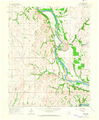
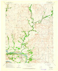 1964 Kaw City1965 Print · USGSKaw City and the Arkansas River valley are shown here in the mid-sixties, just before the landscape was transformed by reservoir construction. Genealogists and local historians can trace the original townsite of Kaw City, the community of Washunga, and the Washunga Cem before their relocation.4 unique versions available
 - 1985 Map of Pawhuska, 1986 Print
 1985 Pawhuska1986 Print · USGSThe Osage Indian Reservation and its tribal capital at Pawhuska are seen here in the mid-1980s as the region's ranching and oil legacies matured. Genealogists and historians can trace family-named sites and vanished industrial tracks near Bigheart, Wynona, and Gray Horse.2 unique versions available
End of results
Showing maps 1-6 of 6
Top cities near Kaw City
- Ponca City historical maps
- Newkirk historical maps
- Fairfax historical maps
- Shidler historical maps
- Burbank historical maps
- Webb City historical maps
See more
Frequently asked questions
- What are the different types of historical maps available for Kaw City?
- What is the oldest map of Kaw City?
- Where can I purchase historical maps of Kaw City for my home or office?
- Where can I download high-res historical maps of Kaw City?
- Are there historical topographic maps available for Kaw City?
- Is there historical aerial imagery available for Kaw City?
- Where are historical maps of Kaw City sourced from?