1970s Maps of Lutie, Wilburton
Explore 2 historic maps of Lutie from the 1970s. These maps offer a rare glimpse into what life looked like during the 1970s — showing old roads, neighborhoods, homes, and landmarks that have changed or disappeared over time.
Whether you're researching your family's past, planning a metal detecting trip, or studying how Lutie's landscape evolved across the 1970s, these high-resolution maps are a powerful tool for exploring the history of this region.
- Focus on a specific era: All maps on this page are from the 1970s, giving you a focused view of this time period.
- See what’s changed: Compare century-old streets, trails, and buildings to today's modern landscape using overlays and satellite layers.
- Research with precision: Use these maps for genealogy, historical research, land use analysis, or educational projects.
- View, download, or print: Maps are fully viewable online in high resolution, and can be downloaded or printed for your own records.
Start exploring Lutie's history through authentic maps from the 1970s. This is your window into the past.
Lutie, Wilburton maps
(2)- 1971 Map of Wilburton, 1973 Print
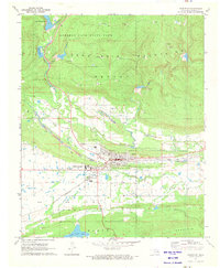 1971 Wilburton1973 Print · USGSWilburton and the surrounding coal and gas lands are captured in the early seventies as industrial mining and higher education shaped the landscape. Genealogists and historians can locate Wilburton Cemetery, the campus of Eastern Oklahoma State College, and the intricate network of Strip Mines and Gas Wells.
 - 1977 Map of Wilburton
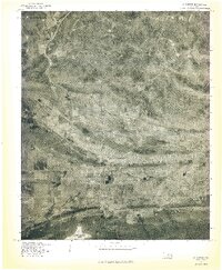 1977 Wilburton1977 Print · USGSWilburton and the surrounding Latimer County landscape are captured during the late seventies in this aerial-derived orthophoto. Researchers can trace the town's expansion and locate local landmarks such as Lake Wayne Wallace and the Sans Bois Mountains.
End of results
Showing maps 1-2 of 2
Top cities near Lutie
- Wilburton historical maps
- Talihina historical maps
- Quinton historical maps
- Red Oak historical maps
- Kinta historical maps
Frequently asked questions
- What are the different types of historical maps available for Lutie?
- What is the oldest map of Lutie?
- Where can I purchase historical maps of Lutie for my home or office?
- Where can I download high-res historical maps of Lutie?
- Are there historical topographic maps available for Lutie?
- Is there historical aerial imagery available for Lutie?
- Where are historical maps of Lutie sourced from?