Old Maps of Logan County, Oklahoma
Explore 155 old maps of Logan County, spanning from 1892 to today. These high-resolution historic maps reveal how streets, neighborhoods, landmarks, and natural features evolved over time — perfect for genealogy, metal detecting, research, and local history exploration.
What you can do with these maps:
- See how Logan County changed over time: Compare historical maps to modern-day views to trace roads, homesites, rail lines & more.
- View detailed metadata: Each map includes creators, publishers, year, scale, and archive source.
- Overlay maps with satellite & LiDAR: Visualize the past alongside modern tools to explore terrain & human change.
- Trusted historical sources: Maps sourced from the USGS, Library of Congress, and other archives.
- Access maps your way: View online, download high-res files, or order prints for personal or research use.
Start exploring old maps of Logan County to uncover forgotten places, hidden landmarks, and the deep history beneath your feet.
Logan County, OK maps
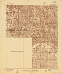
(155)- 1892 Map of Guthrie
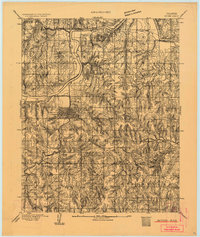 1892 Guthrie1892 Print · USGSGuthrie and the surrounding Logan County landscape are captured here in the early years of the Oklahoma Territory. Researchers can trace the vital Atchison Topeka and Santa Fe RR line and find early settlements like Lowrie and Beulah.
 - 1892 Map of Edmond
 1892 Edmond1892 Print · USGSOklahoma Territory was still in its first years of settlement when this survey was conducted, showing the vital rail corridor through Edmond. Researchers can trace early township boundaries and the paths of the Atchison Topeka and Santa Fe Railroad near Waterloo and Enfield.
 - 1892 Map of Kingfisher, 1957 Print
 1892 Kingfisher1957 Print · USGSOklahoma Territory was in a state of rapid transition during the 1890s as railroads and cattle trails shared the same landscape. Researchers can trace the original Chisholm Trail alongside early settlements like Mathewson and river crossings such as Kirby Ford.
 - 1893 Map of Mulhall
 1893 Mulhall1893 Print · USGSCentral Oklahoma land was newly opened for settlement when these surveyors documented the prairie around Mulhall and Orlando. Genealogists and local historians can trace the early township grids near Clarkson and along the winding Cimarron River.
 - 1893 Map of Lovell
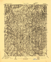
 1893 Lovell1893 Print · USGSOklahoma Territory was still in its infancy when this survey was conducted, showing the land just after the first settlers arrived. Genealogists can trace the early locations of Marshall, Sheridan, and Columbia along the banks of Skeleton Creek.
 - 1895 Map of Kingfisher
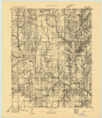
 1895 Kingfisher1895 Print · USGSOklahoma Territory during the mid-1890s reveals a rapidly developing frontier defined by river crossings and expanding rail lines. Genealogists and historians can trace the early foundations of Kingfisher, Elreno, and Yukon alongside historic river crossings like Gould Ford.4 unique versions available
 - 1909 Map of Luther
 1909 Luther1909 Print · USGSDuring the final years of the Oklahoma Territory, this area saw rapid growth as railroads connected towns like Luther and Wellston. Genealogists and historians can locate dozens of early community sites, from the German Church to rural schoolhouses like Peach Grove School and Arbuckle School.2 unique versions available
 - 1909 Map of Perkins
 1909 Perkins1909 Print · USGSOklahoma Territory near the turn of the century is a landscape of new rail-side towns and scattered one-room schoolhouses. Genealogists and historians can trace family roots through dozens of named sites like Vim PO, Mt Bethel Church, and Eagle College School.4 unique versions available
 - 1935 Map of Edmond
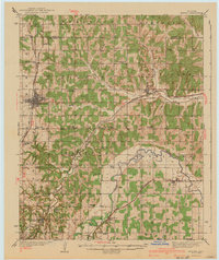
 1935 Edmond1935 Print · USGSEdmond and its surrounding townships are captured in the mid-1930s as a vital transportation hub for central Oklahoma. Genealogists and historians can trace the early path of U S Highway No 66 and locate numerous rural landmarks like Wagner Cem and Mount Zion Sch.2 unique versions available
 - 1940 Map of Edmond
 1940 Edmond1940 Print · USGSOklahoma and Logan Counties are captured here in the years leading up to the war, showing a rural landscape anchored by rail towns. Researchers can trace family history through a dense network of country schools and cemeteries like Sunnyside Sch and Rose Hill Cem.2 unique versions available
 - 1954 Map of Oklahoma City
 1954 Oklahoma City1954 Print · USGSOklahoma City and its surrounding counties are captured here in the early fifties during a period of significant postwar growth. Researchers can trace the development of the Turner Turnpike and locate aviation hubs like Tinker Field or Will Rogers Field.
 - 1955 Map of Enid, 1966 Print
 1955 Enid1966 Print · USGSNorth-central Oklahoma's transition from open plains to the blackjack hills of the Osage Indian Reservation is captured in the mid-1950s. Researchers can trace the development of the Naval Reserve Oil Field, the grounds of Vance AFB, and the early footprints of Tulsa and Stillwater.4 unique versions available
 - 1957 Map of Oklahoma City, 1969 Print
 1957 Oklahoma City1969 Print · USGSCentral Oklahoma is captured here in a period of significant mid-century growth and industrialization. Researchers can trace family roots through numerous rural markers like Memory Lane Cem, New Hope School, and the sprawling grounds of Tinker Air Force Base.3 unique versions available
 - 1958 Map of Enid
 1958 Enid1958 Print · USGSNorthern Oklahoma is mapped here in the late fifties, showcasing a dense network of petroleum production and historic tribal lands. Researchers can trace the legacy of the Osage Indian Reservation, early energy hubs like the Cushing Oil Field, and the Chilocco Indian Agricultural School.2 unique versions available
 - 1963 Map of Oklahoma City
 1963 Oklahoma City1963 Print · USGSCentral Oklahoma in the early sixties showcases a landscape of rapid suburban growth and established oil production. Researchers can trace historic rail lines like the Chicago Rock Island and Pacific RR or locate rural landmarks such as Mayflower School and Bethel Church.
 - 1966 Map of Arcadia, 1967 Print
 1966 Arcadia1967 Print · USGSMid-century Oklahoma County is defined here by the intersection of the Missouri - Kansas - Texas railroad and early energy development. Genealogists and historians can trace family locations through numerous sites like Donnell Cem, IOOF Cem, and the growing community at Lake Hiwassee.3 unique versions available
 - 1966 Map of Edmond, 1967 Print
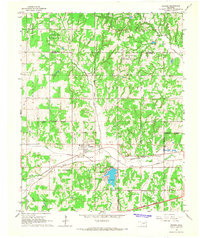
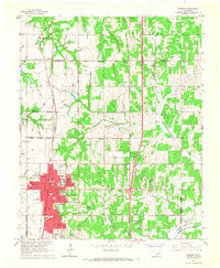 1966 Edmond1967 Print · USGSEdmond and the surrounding rural townships are shown during a period of significant suburban growth in the mid-1960s. Researchers can trace the development of Central State College or locate family sites at Waterloo Cem and Pleasant Hill Cem.3 unique versions available
 - 1966 Map of Bethany NE, 1967 Print
 1966 Bethany NE1967 Print · USGSOklahoma and Logan counties were in the midst of a suburban transition during the mid-sixties as municipal boundaries expanded. Local historians and genealogists can trace the rural roots of the area through landmarks like Christner Cem, Deer Creek Sch, and the Higbee Community Hall.3 unique versions available
 - 1966 Map of Luther, 1967 Print
 1966 Luther1967 Print · USGSThe town of Luther in the mid-sixties was a crossroads of rail commerce and active energy production. Genealogists and historians can trace family locations near several burial sites like Reunion and Tillman or follow the path of the St Louis-San Francisco railroad.3 unique versions available
 - 1966 Map of Piedmont, 1967 Print
 1966 Piedmont1967 Print · USGSMid-century Piedmont and its surrounding rural townships appear here during a period of urban expansion and petroleum development. Researchers can find old family cemeteries like Kansas Cem, trace the Old Railroad Grade, and locate the early infrastructure of the West Edmond Oil and Gas Field.3 unique versions available
 - 1969 Map of Crescent NW, 1972 Print
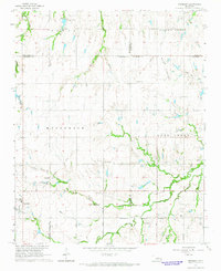
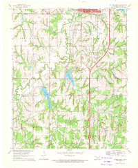
 1969 Crescent NW1972 Print · USGSKingfisher and Logan counties are shown in the late sixties as the regional economy balanced agriculture with energy production. Genealogists can locate family-named sites like Borelli and Wandel or trace burial sites at Oak Vale Cem and Oak Grove Cem.
 - 1970 Map of Navina, 1971 Print
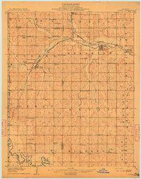
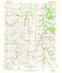
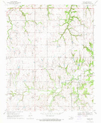 1970 Navina1971 Print · USGSLogan County farmland and the community of Navina are captured here in 1970, showing the region as its rail-dependent past gave way to modern utility corridors. Researchers can trace the path of an Old Railroad Grade and locate local landmarks like Harmony Cem and Iron Mound.2 unique versions available
 - 1970 Map of Guthrie North, 1972 Print
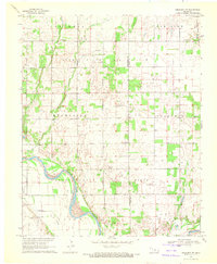
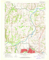 1970 Guthrie North1972 Print · USGSNorth of Guthrie in the early 1970s, the river valley landscape is shaped by the sweeping Cimarron River and its rail corridors. Researchers can locate family landmarks like Summit View Cemetery, the Masonic Temple, and small settlements at Lawrie and Camp Joy.3 unique versions available
 - 1970 Map of Guthrie South, 1972 Print
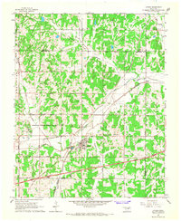
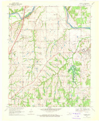
 1970 Guthrie South1972 Print · USGSLogan County, Oklahoma, comes into focus in the early seventies as the area around Guthrie balances its oil production and aviation growth. Researchers can trace family history through Seward Cem, find the old Faubion Sch, or follow the old RR grade.3 unique versions available
 - 1970 Map of Langston, 1972 Print
 1970 Langston1972 Print · USGSThe Oklahoma countryside near the Logan and Payne county line is captured here just as the landscape was being reshaped by the Langston Dam Under Constr. Researchers can locate Langston University, several family-named community halls, and numerous cemeteries like Mt Hope Cem and Holy Family Cem.3 unique versions available
Showing maps 1-25 of 155
Top cities of Logan County
- Guthrie historical maps
- Langston historical maps
- Crescent historical maps
- Cedar Valley historical maps
- Coyle historical maps
- Marshall historical maps
See more
Frequently asked questions
- What are the different types of historical maps available for Logan County?
- What is the oldest map of Logan County?
- Where can I purchase historical maps of Logan County for my home or office?
- Where can I download high-res historical maps of Logan County?
- Are there historical topographic maps available for Logan County?
- Is there historical aerial imagery available for Logan County?
- Where are historical maps of Logan County sourced from?