1892 Map of Guthrie
USGS Topo · Published 1892About this map
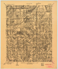
Guthrie serves as the central hub of this early Oklahoma Territory landscape, just years after the Land Run of 1889. The settlement pattern reflects the rapid development of the era, with the Atchison Topeka and Santa Fe RR providing the primary transit corridor through the region. North of the townsite, the Cimarron River winds through the terrain, featuring the noted Camp Russell Ford. Small outlying settlements such as Lowrie, Doddsworth, and Springvale are documented here, marking the early homesteading and ranching efforts in the vicinity of the Osage Hills. The topography reveals a complex network of drainages feeding into Bear Creek, illustrating the natural challenges faced by early settlers as they established the county's first rural communities and post offices.
Find a feature on this map
17 named features on this map. Tap any name to fly to it.
Don’t see what you’re looking for? This feature index may not catch every label — zoom into the map to look around manually.
Map Details
Editions of this 1892 Guthrie Map
This is the sole edition of this map. No revisions or reprints were ever made.
Historical Maps of Guthrie Through Time
1 maps found