
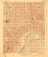
1940 Map of Edmond
USGS Topo · Published 1940About this map
The growing town of Edmond serves as a central hub in this survey, situated at the intersection of the Atchison Topeka and Santa Fe railroad and local roads. The landscape is defined by the winding course of the North Canadian River and the Deep Fork, where small settlements like Arcadia and Jones are established along the Missouri Kansas Texas and St Louis San Francisco rail lines.
Find a feature on this map
51 named features on this map. Tap any name to fly to it.
Don’t see what you’re looking for? This feature index may not catch every label — zoom into the map to look around manually.
Map Details
Editions of this 1940 Edmond Map
2 editions found
Other maps of this area

1892 · Moore
USGS Topo · 1:62,500

1892 · Guthrie
USGS Topo · 1:62,500

1892 · Edmond
USGS Topo · 1:62,500

1892 · Kingfisher
USGS Topo · 1:125,000

1893 · Oklahoma City
USGS Topo · 1:62,500

1895 · Kingfisher
USGS Topo · 1:125,000

1898 · Purcell
USGS Topo · 1:125,000

1904 · Chickasha
USGS Topo · 1:125,000

1909 · Luther
USGS Topo · 1:62,500

1909 · Perkins
USGS Topo · 1:62,500