1898 Map of Purcell
USGS Topo · Published 1898About this map
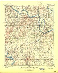
Purcell stands as a primary settlement along the western bank of the Canadian River in this late nineteenth-century topographic study. The landscape is defined by the drainage of Walnut Creek, which cuts through the territory toward the river's edge. This map, surveyed by R.A. Farmer under the direction of C.H. Fitch, highlights the critical transportation infrastructure of the era, specifically the route of the G C and S F R R. The detailed topography shows the transitional terrain of the Oklahoma and Indian Territory borderlands, capturing the spatial relationship between the emerging rail corridor and the natural hydrology of the region before further twentieth-century development transformed the river valley.
Find a feature on this map
4 named features on this map. Tap any name to fly to it.
Don’t see what you’re looking for? This feature index may not catch every label — zoom into the map to look around manually.
Map Details
Editions of this 1898 Purcell Map
This is the sole edition of this map. No revisions or reprints were ever made.
Historical Maps of Oklahoma City Through Time
4 maps found