1896 Map of Seminole and Prague
USGS Topo · Published 1896About this map
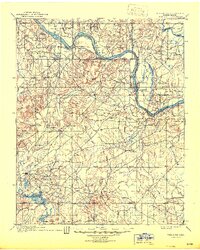
Indian Oklahoma Territory is documented here during a pivotal era of tribal sovereignty and transition, as surveyed by C.H. Fitch and Van. H. Manning. The landscape is defined by its complex political geography, specifically the Pottawatomie County Creek Nation Boundary Line and the Seminole Creek Nation Boundary. These lines partition the rolling terrain north of the North Fork Canadian River, where early settlements like Mekosukey and Heliswa served as local hubs. The drainage patterns of Wewoka, Salt, and Deep creeks illustrate the natural water resources that shaped settlement before Oklahoma achieved statehood. This advance sheet captures the region's topography just as modern administrative boundaries were beginning to overlay traditional tribal lands.
Find a feature on this map
10 named features on this map. Tap any name to fly to it.
Don’t see what you’re looking for? This feature index may not catch every label — zoom into the map to look around manually.
Map Details
Editions of this 1896 Seminole and Prague Map
This is the sole edition of this map. No revisions or reprints were ever made.
Historical Maps of Shawnee Through Time
4 maps found