1900-1909 Maps of Logan County, Oklahoma
Explore 2 historic maps of Logan County from 1900-1909. These maps offer a rare glimpse into what life looked like during the 1900s — showing old roads, neighborhoods, homes, and landmarks that have changed or disappeared over time.
Whether you're researching your family's past, planning a metal detecting trip, or studying how Logan County's landscape evolved across the 1900s, these high-resolution maps are a powerful tool for exploring the history of this region.
- Focus on a specific era: All maps on this page are from the 1900s, giving you a focused view of this time period.
- See what’s changed: Compare century-old streets, trails, and buildings to today's modern landscape using overlays and satellite layers.
- Research with precision: Use these maps for genealogy, historical research, land use analysis, or educational projects.
- View, download, or print: Maps are fully viewable online in high resolution, and can be downloaded or printed for your own records.
Start exploring Logan County's history through authentic maps from the 1900s. This is your window into the past.
Logan County, OK maps
(2)- 1909 Map of Luther
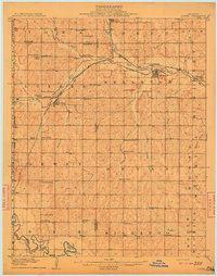 1909 Luther1909 Print · USGSDuring the final years of the Oklahoma Territory, this area saw rapid growth as railroads connected towns like Luther and Wellston. Genealogists and historians can locate dozens of early community sites, from the German Church to rural schoolhouses like Peach Grove School and Arbuckle School.2 unique versions available
 - 1909 Map of Perkins
 1909 Perkins1909 Print · USGSOklahoma Territory near the turn of the century is a landscape of new rail-side towns and scattered one-room schoolhouses. Genealogists and historians can trace family roots through dozens of named sites like Vim PO, Mt Bethel Church, and Eagle College School.4 unique versions available
End of results
Showing maps 1-2 of 2
Top cities of Logan County
- Guthrie historical maps
- Langston historical maps
- Crescent historical maps
- Cedar Valley historical maps
- Coyle historical maps
- Marshall historical maps
See more
Frequently asked questions
- What are the different types of historical maps available for Logan County?
- What is the oldest map of Logan County?
- Where can I purchase historical maps of Logan County for my home or office?
- Where can I download high-res historical maps of Logan County?
- Are there historical topographic maps available for Logan County?
- Is there historical aerial imagery available for Logan County?
- Where are historical maps of Logan County sourced from?