1970s Maps of Afton, Oklahoma
Explore 1 historic maps of Afton from the 1970s. These maps offer a rare glimpse into what life looked like during the 1970s — showing old roads, neighborhoods, homes, and landmarks that have changed or disappeared over time.
Whether you're researching your family's past, planning a metal detecting trip, or studying how Afton's landscape evolved across the 1970s, these high-resolution maps are a powerful tool for exploring the history of this region.
- Focus on a specific era: All maps on this page are from the 1970s, giving you a focused view of this time period.
- See what’s changed: Compare century-old streets, trails, and buildings to today's modern landscape using overlays and satellite layers.
- Research with precision: Use these maps for genealogy, historical research, land use analysis, or educational projects.
- View, download, or print: Maps are fully viewable online in high resolution, and can be downloaded or printed for your own records.
Start exploring Afton's history through authentic maps from the 1970s. This is your window into the past.
Afton, OK maps
(1)- 1971 Map of Afton, 1973 Print
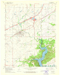 1971 Afton1973 Print · USGSAfton and Bernice sit at the crossroads of Northeastern Oklahoma in the early 1970s, where the turnpike and rail lines meet the Grand Lake shoreline. Genealogists can locate family landmarks like Mt Hope Cem and Sixkiller Cem near the winding Horse Creek.
End of results
Showing maps 1-1 of 1
Top cities near Afton
- Miami historical maps
- Grove historical maps
- Vinita historical maps
- Fairland historical maps
- Langley historical maps
- Welch historical maps
See more
Top neighborhoods of Afton
- Afton Original historical maps
- Afton Original historical maps
- Afton Original historical maps
- Crowell historical maps
- Crowell historical maps
- Afton Original historical maps
See more
Frequently asked questions
- What are the different types of historical maps available for Afton?
- What is the oldest map of Afton?
- Where can I purchase historical maps of Afton for my home or office?
- Where can I download high-res historical maps of Afton?
- Are there historical topographic maps available for Afton?
- Is there historical aerial imagery available for Afton?
- Where are historical maps of Afton sourced from?