1900s (20th Century) Maps of Francis, Oklahoma
Explore 6 historic maps of Francis from the 1900s (20th Century). These maps offer a rare glimpse into what life looked like during the 1900s — showing old roads, neighborhoods, homes, and landmarks that have changed or disappeared over time.
Whether you're researching your family's past, planning a metal detecting trip, or studying how Francis's landscape evolved across the 1900s, these high-resolution maps are a powerful tool for exploring the history of this region.
- Focus on a specific era: All maps on this page are from the 1900s, giving you a focused view of this time period.
- See what’s changed: Compare century-old streets, trails, and buildings to today's modern landscape using overlays and satellite layers.
- Research with precision: Use these maps for genealogy, historical research, land use analysis, or educational projects.
- View, download, or print: Maps are fully viewable online in high resolution, and can be downloaded or printed for your own records.
Start exploring Francis's history through authentic maps from the 1900s. This is your window into the past.
Francis, OK maps
(6)- 1901 Map of Stonewall
 1901 Stonewall1901 Print · USGSBefore Oklahoma statehood, this late-century survey captures the Chickasaw Nation and Seminole Nation borderlands in high detail. Researchers can locate early schools like Collins Institute and trace the paths between settlements such as Stonewall, Ada, and Fitzhugh.4 unique versions available
 - 1957 Map of Ardmore, 1968 Print
 1957 Ardmore1968 Print · USGSSouth-central Oklahoma in the late fifties was a landscape of rising reservoir waters and expanding rail lines. Genealogists and historians can trace the foundations of Ardmore and Duncan or locate early recreation sites at Platt National Park and Lake Murray State Park.3 unique versions available
 - 1958 Map of Sasakwa, 1959 Print
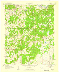
 1958 Sasakwa1959 Print · USGSThe borderlands of Seminole and Pontotoc counties are captured here in the late fifties, defined by the winding Canadian River and the St Louis San Francisco railroad. Researchers can locate many family-named landmarks and historical sites like Old Mission Cem, Gully Sch, and Sasakwa.3 unique versions available
 - 1958 Map of Francis, 1959 Print
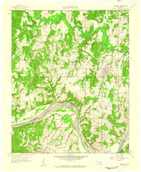
 1958 Francis1959 Print · USGSOklahoma's petroleum and rail history intersect here in the late fifties, centered on the railroad hub at Francis. Genealogists and local historians can trace family roots through numerous sites like Oakman Cem, Lovelady Ch, and Homer.3 unique versions available
 - 1963 Map of Ardmore
 1963 Ardmore1963 Print · USGSSouthern Oklahoma during the early sixties shows a landscape defined by the Arbuckle Mountains and a booming energy economy. Genealogists and historians can trace family-named sites across the Ardmore Oil Field, find old schools like Southeastern State College, or locate historic markers such as Boggy Depot State Park.2 unique versions available
 - 1990 Map of Ada
 1990 Ada1990 Print · USGSOklahoma's South Central plains and woodlands appear in high detail during the late twentieth century. Genealogists and historians can trace family roots in Ada, locate local institutions like East Central State University, and explore regional hubs like Sulphur or Stonewall.
End of results
Showing maps 1-6 of 6
Top cities near Francis
- Ada historical maps
- Holdenville historical maps
- Konawa historical maps
- Byng historical maps
- Allen historical maps
- Stonewall historical maps
See more
Frequently asked questions
- What are the different types of historical maps available for Francis?
- What is the oldest map of Francis?
- Where can I purchase historical maps of Francis for my home or office?
- Where can I download high-res historical maps of Francis?
- Are there historical topographic maps available for Francis?
- Is there historical aerial imagery available for Francis?
- Where are historical maps of Francis sourced from?