1960s Maps of Waynoka, Oklahoma
Explore 2 historic maps of Waynoka from the 1960s. These maps offer a rare glimpse into what life looked like during the 1960s — showing old roads, neighborhoods, homes, and landmarks that have changed or disappeared over time.
Whether you're researching your family's past, planning a metal detecting trip, or studying how Waynoka's landscape evolved across the 1960s, these high-resolution maps are a powerful tool for exploring the history of this region.
- Focus on a specific era: All maps on this page are from the 1960s, giving you a focused view of this time period.
- See what’s changed: Compare century-old streets, trails, and buildings to today's modern landscape using overlays and satellite layers.
- Research with precision: Use these maps for genealogy, historical research, land use analysis, or educational projects.
- View, download, or print: Maps are fully viewable online in high resolution, and can be downloaded or printed for your own records.
Start exploring Waynoka's history through authentic maps from the 1960s. This is your window into the past.
Waynoka, OK maps
(2)- 1969 Map of Waynoka East, 1971 Print
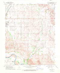 1969 Waynoka East1971 Print · USGSWoods County in the late sixties is revealed here as a landscape of rail transit and river boundaries. Genealogists and local historians can trace family ties to landmarks like Walnut Grove Cem, Rose Valley Sch, and the busy Waynoka rail corridor.
 - 1969 Map of Waynoka West, 1971 Print
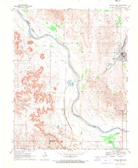 1969 Waynoka West1971 Print · USGSWoods County in the late sixties reveals a landscape defined by the winding Cimarron River and the bustling rail operations in Waynoka. Genealogists and historians can trace the rail corridor through Heman or locate the early layout of the Little Sahara State Recreation Area.2 unique versions available
End of results
Showing maps 1-2 of 2
Top cities near Waynoka
Frequently asked questions
- What are the different types of historical maps available for Waynoka?
- What is the oldest map of Waynoka?
- Where can I purchase historical maps of Waynoka for my home or office?
- Where can I download high-res historical maps of Waynoka?
- Are there historical topographic maps available for Waynoka?
- Is there historical aerial imagery available for Waynoka?
- Where are historical maps of Waynoka sourced from?