1980s Maps of Lime, Oregon
Explore 2 historic maps of Lime from the 1980s. These maps offer a rare glimpse into what life looked like during the 1980s — showing old roads, neighborhoods, homes, and landmarks that have changed or disappeared over time.
Whether you're researching your family's past, planning a metal detecting trip, or studying how Lime's landscape evolved across the 1980s, these high-resolution maps are a powerful tool for exploring the history of this region.
- Focus on a specific era: All maps on this page are from the 1980s, giving you a focused view of this time period.
- See what’s changed: Compare century-old streets, trails, and buildings to today's modern landscape using overlays and satellite layers.
- Research with precision: Use these maps for genealogy, historical research, land use analysis, or educational projects.
- View, download, or print: Maps are fully viewable online in high resolution, and can be downloaded or printed for your own records.
Start exploring Lime's history through authentic maps from the 1980s. This is your window into the past.
Lime, OR maps
(2)- 1980 Map of Brogan, 1997 Print
 1980 Brogan1997 Print · USGSThe Oregon-Idaho borderlands come alive in this late-century survey of the high desert and river valleys. Researchers can trace the legacy of ranching and transport through sites like Malheur City, the Union Pacific rail lines, and the Snake River crossings.
 - 1988 Map of Lime
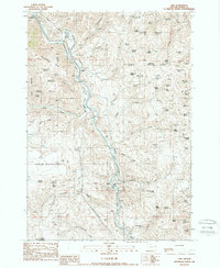 1988 Lime1988 Print · USGSThe Burnt River canyon in the late eighties serves as a rugged industrial corridor for mining and transit. Researchers can trace the path of the Oregon Trail alongside the limestone operations at Lime and the historic settlement of Weatherby.
End of results
Showing maps 1-2 of 2
Top cities near Lime
Frequently asked questions
- What are the different types of historical maps available for Lime?
- What is the oldest map of Lime?
- Where can I purchase historical maps of Lime for my home or office?
- Where can I download high-res historical maps of Lime?
- Are there historical topographic maps available for Lime?
- Is there historical aerial imagery available for Lime?
- Where are historical maps of Lime sourced from?