Old Maps of Columbia County, Oregon
Explore 147 old maps of Columbia County, spanning from 1915 to today. These high-resolution historic maps reveal how streets, neighborhoods, landmarks, and natural features evolved over time — perfect for genealogy, metal detecting, research, and local history exploration.
What you can do with these maps:
- See how Columbia County changed over time: Compare historical maps to modern-day views to trace roads, homesites, rail lines & more.
- View detailed metadata: Each map includes creators, publishers, year, scale, and archive source.
- Overlay maps with satellite & LiDAR: Visualize the past alongside modern tools to explore terrain & human change.
- Trusted historical sources: Maps sourced from the USGS, Library of Congress, and other archives.
- Access maps your way: View online, download high-res files, or order prints for personal or research use.
Start exploring old maps of Columbia County to uncover forgotten places, hidden landmarks, and the deep history beneath your feet.
Columbia County, OR maps
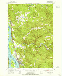
(147)- 1915 Map of Hillsboro
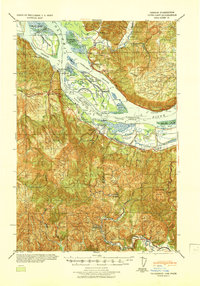
 1915 Hillsboro1915 Print · USGSThe Tualatin Valley and the confluence of the Columbia and Willamette rivers are shown here at the peak of the electric rail era. Researchers can trace historic family schoolhouses like Mason Hill School and vanished landings such as Blurock Landing.
 - 1918 Map of Hillsboro
 1918 Hillsboro1918 Print · USGSThe Tualatin Valley and Columbia riverfront are seen here during the heyday of the electric interurban and steam rail era. Researchers can trace family sites at Mason Hill School, identify the river life of Sauvie Island, or locate vanished stops like Cornelius Pass.4 unique versions available
 - 1919 Map of Mayger
 1919 Mayger1919 Print · USGSThe Columbia River shoreline in the years following the Great War reveals a landscape of tidal sloughs and nascent settlements. Researchers can trace the early rail corridor of the S. P. & S. R. R. and locate riverfront sites like Mayger, Cleavelands Ldg., and Inglis.
 - 1921 Map of Kalama
 1921 Kalama1921 Print · USGSThe Columbia River corridor is captured here in the early twenties, showing the vital rail and road networks connecting Washington and Oregon. Genealogists and historians can locate riverside settlements like Carrolls PO, industrial landmarks like the Ostrander Tunnel, and early routes like the Pacific Highway.
 - 1922 Map of St. Helens
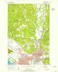
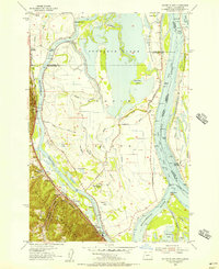
 1922 St. Helens1922 Print · USGSThe Columbia River valley in the early twenties was a hub of logging and river commerce. Genealogists can trace family roots through old post offices like Yankton P.O. and Warren P.O. or locate historic industry at the Dupont Powder Co. site.
 - 1940 Map of Hillsboro
 1940 Hillsboro1940 Print · USGSThe Tualatin Valley and the Columbia River confluence meet in this 1940 survey of the Hillsboro and North Portland region. Researchers can trace early twentieth-century rail lines like the Oregon Electric or locate historic rural landmarks such as Mountain View Cemetery and the Mason Hill School.
 - 1940 Map of Vernonia, 1941 Print
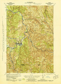
 1940 Vernonia1941 Print · USGSNorthwestern Oregon’s timber country comes into focus in this 1940 survey, showing the river-valley settlements just before the Second World War. Researchers can trace early rural life through landmarks like Pleasant Hill School, the town of Vernonia, and the Catherwood Lookout.
 - 1941 Map of Keasey
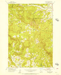
 1941 Keasey1941 Print · USGSThe timber and rail economy of northwest Oregon is captured here just before the war. Trace the path of the Oregon American Lumber Co railroad and locate family landmarks like A W Nelsons Farm and the Winema Sch.
 - 1941 Map of St Helens
 1941 St Helens1941 Print · USGSThe Columbia River waterfront near St. Helens was a thriving industrial and agricultural corridor just before the war. Trace old rail stops at Honeymoon Sta, rural schoolhouses like Shilo Basin Sch, and the shifting river islands from Deer Island to Bachelor Island.
 - 1941 Map of Clatskanie
 1941 Clatskanie1941 Print · USGSThe Columbia River shoreline and the timberlands of Columbia County are captured here just as the nation entered the war. Genealogists and researchers can trace rural life through landmarks like Crossing Cem, Erickson School, and the lookout at Benson L O.
 - 1941 Map of Cathlamet
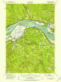
 1941 Cathlamet1941 Print · USGSThe Lower Columbia River reaches its widest breadth here during the early 1940s, connecting riverside timber and milling hubs. Researchers can trace the family names of early settlers on Puget Island or find riverfront landmarks like Ankeny Landing and Clifton.
 - 1943 Map of Vernonia
 1943 Vernonia1943 Print · USGSUpper Nehalem Valley life in the early 1940s is defined here by the logging railways and riverside hamlets of Columbia County. You can trace the United Railways line into Vernonia or locate vanished rural schoolhouses like Beaver Creek Sch and Natal Sch.
 - 1943 Map of Keasey
 1943 Keasey1943 Print · USGSThe timber country of the northern Oregon Coast Range comes alive in the early 1940s as loggers worked the Nehalem River basin. Researchers can trace the industrial footprint of the Oregon American Lumber Company and find small outposts like Birkenfeld, Keasey, and Neverstill.
 - 1943 Map of St Helens
 1943 St Helens1943 Print · USGSThe Columbia River corridor during the mid-forties shows a bustling network of riverfront towns and upland settlements. Researchers can trace historic river landings like Caples Landing alongside rural landmarks such as Yankton, Trenholm, and Shilo Basin Sch.
 - 1948 Map of Vancouver, 1957 Print
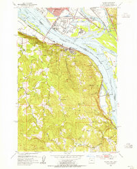
 1948 Vancouver1957 Print · USGSPost-war growth transforms the river valleys of the Pacific Northwest as the timber and rail economy thrives. Trace family roots in Tillamook or Oregon City, and locate vanished landmarks like the spit at Bayocean or the Skamania Mine.
 - 1950 Map of Vancouver
 1950 Vancouver1950 Print · USGSCoastal Oregon and the lower Columbia River valley are captured in detail just after the war. Researchers can trace historic rail routes like the Southern Pacific or locate early settlements such as Vernonia, Gaston, and the Grand Ronde Indian Reservation.
 - 1950 Map of Vancouver, 1951 Print
 1950 Vancouver1951 Print · USGSThe Pacific Northwest urban corridor meets the rugged coast in the years following the war, showing the expansion of Portland and Vancouver. Genealogists and historians can trace the reach of the Southern Pacific RR and locate coastal communities like Tillamook, Seaside, and Tolovana Park.
 - 1952 Map of Clatskanie, 1954 Print
 1952 Clatskanie1954 Print · USGSThe lower Columbia River basin comes to life in the early fifties, showing the intricate dikes and rail lines of the Oregon and Washington border. Genealogists can locate family sites at Bryant Cemetery or trace the vanished streets of Swedetown.3 unique versions available
 - 1953 Map of Hoquiam
 1953 Hoquiam1953 Print · USGSSouthwest Washington in the early fifties shows a landscape shaped by timber, rail, and river commerce from the coast to the Cascades. Genealogists and historians can trace the development of timber towns like Ryderwood and the industrial hubs of Hoquiam and Kelso.2 unique versions available
 - 1953 Map of Rainier, 1955 Print
 1953 Rainier1955 Print · USGSThe Columbia River waterfront at the start of the fifties reveals a heavy industrial corridor between Oregon and Washington. Genealogists and local historians can locate early landmarks like Hudson Cem, Neer City Sch, and the Reuben (site).4 unique versions available
 - 1953 Map of Kalama, 1955 Print
 1953 Kalama1955 Print · USGSThe Columbia River corridor in the early fifties shows a bustling network of rail and river commerce. Genealogists can trace the rural life of Rose Valley through the Rose Valley School and locate ancestors at Mt Pleasant Cem.5 unique versions available
 - 1953 Map of Cathlamet, 1955 Print
 1953 Cathlamet1955 Print · USGSThe Lower Columbia River reaches a peak of commercial and timber activity during the early fifties. Genealogists and local historians can trace family roots through riverside settlements like Cathlamet and Westport, or find Greenwood Cem and Fishhawk Cem.4 unique versions available
 - 1953 Map of Kelso, 1955 Print
 1953 Kelso1955 Print · USGSThe industrial corridor of the Cowlitz and Columbia rivers comes alive in the mid-1950s, showing the early development of the Longview-Kelso area. Researchers can trace the layout of local institutions like R A Long HS or find rural landmarks like Sandy Bend School and Huntington Rock.3 unique versions available
 - 1953 Map of Dixie Mountain, 1956 Print
 1953 Dixie Mountain1956 Print · USGSThe Tualatin Mountains in the early 1950s were a landscape of high ranches and small rural schools along the tri-county border. Genealogists and historians can trace family-named routes like Moreland Road to find Mountain View Cemetery or the site of Mason Hill Sch (Aban'd).
 - 1954 Map of Sauvie Island, 1956 Print
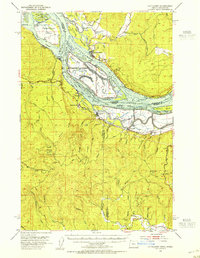
 1954 Sauvie Island1956 Print · USGSSauvie Island and the Columbia River confluence are shown in detail during the mid-fifties, capturing a landscape of levees, sloughs, and river landings. Trace family roots and local history at Burlington, the Sauvie Island School, and the Spokane Portland and Seattle RR line.
Showing maps 1-25 of 147
Top cities of Columbia County
- Saint Helens historical maps
- Scappoose historical maps
- Vernonia historical maps
- Columbia City historical maps
- Rainier historical maps
- Clatskanie historical maps
See more
Frequently asked questions
- What are the different types of historical maps available for Columbia County?
- What is the oldest map of Columbia County?
- Where can I purchase historical maps of Columbia County for my home or office?
- Where can I download high-res historical maps of Columbia County?
- Are there historical topographic maps available for Columbia County?
- Is there historical aerial imagery available for Columbia County?
- Where are historical maps of Columbia County sourced from?