1960s Maps of Columbia County, Oregon
Explore 5 historic maps of Columbia County from the 1960s. These maps offer a rare glimpse into what life looked like during the 1960s — showing old roads, neighborhoods, homes, and landmarks that have changed or disappeared over time.
Whether you're researching your family's past, planning a metal detecting trip, or studying how Columbia County's landscape evolved across the 1960s, these high-resolution maps are a powerful tool for exploring the history of this region.
- Focus on a specific era: All maps on this page are from the 1960s, giving you a focused view of this time period.
- See what’s changed: Compare century-old streets, trails, and buildings to today's modern landscape using overlays and satellite layers.
- Research with precision: Use these maps for genealogy, historical research, land use analysis, or educational projects.
- View, download, or print: Maps are fully viewable online in high resolution, and can be downloaded or printed for your own records.
Start exploring Columbia County's history through authentic maps from the 1960s. This is your window into the past.
Columbia County, OR maps
(5)- 1961 Map of Dixie Mountain
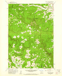 1961 Dixie Mountain1961 Print · USGSThe rural highlands where Columbia and Washington counties meet are captured here in the early sixties. Researchers can locate family landmarks like Dixie Ranch, the Saint Wenceslaus Cem, and the old Wallace Sch among the timbered ridges.4 unique versions available
 - 1961 Map of Sauvie Island, 1962 Print
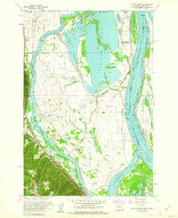 1961 Sauvie Island1962 Print · USGSAlong the Columbia River in the early sixties, the water-bound culture of the island is documented in high detail. Researchers can trace the Spokane Portland and Seattle RR through Holbrook and find local landmarks like Sauvie Island Ch.4 unique versions available
 - 1961 Map of Hillsboro, 1963 Print
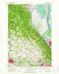 1961 Hillsboro1963 Print · USGSThe Tualatin Valley and Columbia River bottomlands appear in the early sixties as industrial expansion meets established farm country. Trace old rail lines and family history at Tualatin Plains Cem, North Plains, and the Meeks Land Claim Historical Marker.2 unique versions available
 - 1962 Map of Hoquiam
 1962 Hoquiam1962 Print · USGSSouthwest Washington in the late fifties is defined by the bustling timber ports of Hoquiam and the rail-linked commerce of the interior valleys. Genealogists and historians can trace the early footprints of settlements like Raymond and Pe Ell, or locate family sites at Grand Mound Cem and Odd Fellows Cem.
 - 1964 Map of Vancouver
 1964 Vancouver1964 Print · USGSThe Pacific Northwest interior and coast are shown here in the 1960s, from the Portland metropolitan hub to the rugged Pacific shoreline. Researchers can trace the legacy of the Grand Ronde Indian Reservation, the early layout of McMinnville, and the maritime approaches near Tillamook Head.
End of results
Showing maps 1-5 of 5
Top cities of Columbia County
- Saint Helens historical maps
- Scappoose historical maps
- Vernonia historical maps
- Columbia City historical maps
- Rainier historical maps
- Clatskanie historical maps
See more
Frequently asked questions
- What are the different types of historical maps available for Columbia County?
- What is the oldest map of Columbia County?
- Where can I purchase historical maps of Columbia County for my home or office?
- Where can I download high-res historical maps of Columbia County?
- Are there historical topographic maps available for Columbia County?
- Is there historical aerial imagery available for Columbia County?
- Where are historical maps of Columbia County sourced from?