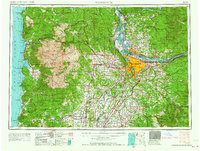
1964 Map of Vancouver
USGS Topo · Published 1964About this map
The Columbia River and Willamette River serve as the primary conduits for settlement and industry on this mid-century survey, anchoring the urban center of Portland and Vancouver. To the west, the landscape transitions from the agricultural heart of the Yamhill Valley, with towns like McMinnville, Dayton, and Lafayette, toward the densely forested Coast Range. This area is characterized by the massive extent of the Siuslaw National Forest and the Grand Ronde Indian Reservation, where logging and tribal lands intersect with coastal communities such as Tillamook and Seaside.
Find a feature on this map
161 named features on this map. Tap any name to fly to it.
Don’t see what you’re looking for? This feature index may not catch every label — zoom into the map to look around manually.
Map Details
Editions of this 1964 Vancouver Map
This is the sole edition of this map. No revisions or reprints were ever made.
Other maps of this area

1897 · Portland
USGS Topo · 1:62,500

1905 · Portland
USGS Topo · 1:62,500
1911 · Boring
USGS Topo · 1:48,000
1914 · Boring
USGS Topo · 1:62,500

1914 · Oregon City
USGS Topo · 1:62,500
1915 · Rickreall
USGS Topo · 1:31,680

1915 · Hillsboro
USGS Topo · 1:62,500
1915 · Eola
USGS Topo · 1:31,680

1916 · Tualatin
USGS Topo · 1:62,500

1916 · Estacada
USGS Topo · 1:125,000