
1911 Map of Boring
USGS Topo · Published 1911About this map
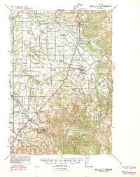
The Portland and Oregon City Railway winds through the hills of Clackamas County, providing a primary transportation link between the growing settlements of Gresham and Boring during the early twentieth century. This survey reveals a landscape transitioning from pioneer homesteads to established agricultural communities, marked by an infrastructure of local education and faith. Schools such as Sycamore School, Buckley School, and Pleasant School are distributed across the terrain, serving the families of Powell Valley and Pleasant Home.
Find a feature on this map
37 named features on this map. Tap any name to fly to it.
Don’t see what you’re looking for? This feature index may not catch every label — zoom into the map to look around manually.
Map Details
Editions of this 1911 Boring Map
This is the sole edition of this map. No revisions or reprints were ever made.
Other maps of this area

1897 · Portland
USGS Topo · 1:62,500

1905 · Portland
USGS Topo · 1:62,500

1914 · Boring
USGS Topo · 1:62,500

1914 · Oregon City
USGS Topo · 1:62,500

1916 · Estacada
USGS Topo · 1:125,000

1918 · Troutdale
USGS Topo · 1:62,500

1934 · Troutdale
USGS Topo · 1:48,000

1939 · Molalla
USGS Topo · 1:62,500

1939 · Oregon City
USGS Topo · 1:62,500
1940 · Molalla
USGS Topo · 1:62,500