
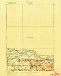
1918 Map of Troutdale
USGS Topo · Published 1918About this map
The confluence of the Sandy R and the Columbia River forms the heart of this 1916 survey, a landscape defined by its vital transport corridors and early agricultural settlements. The Oregon-Washington Railroad and Navigation Company tracks run parallel to the river, serving hubs like Troutdale and Fairview, while the Portland Railway Light and Power Co line extends south toward Gresham. A notable institutional presence is found at the Multnomah County Farm near the riverbank. Further inland, the landscape transitions from river bottomlands near Sundial Lake and Government Island to the higher elevations of Corbett Heights and Chamberlain Hill. This early edition details the intricate network of local education and community life, marked by the Pleasant View School and Hurlburt School, alongside landmarks like Twelvemile Corner and Cemetery Hill.
Find a feature on this map
50 named features on this map. Tap any name to fly to it.
Don’t see what you’re looking for? This feature index may not catch every label — zoom into the map to look around manually.
Map Details
Editions of this 1918 Troutdale Map
2 editions found
Other maps of this area

1897 · Portland
USGS Topo · 1:62,500

1905 · Portland
USGS Topo · 1:62,500

1911 · Boring
USGS Topo · 1:48,000

1914 · Boring
USGS Topo · 1:62,500

1914 · Oregon City
USGS Topo · 1:62,500

1916 · Estacada
USGS Topo · 1:125,000

1934 · Troutdale
USGS Topo · 1:48,000

1939 · Oregon City
USGS Topo · 1:62,500

1940 · Lookout Mtn
USGS Topo · 1:62,500

1940 · Boring
USGS Topo · 1:62,500