
1940 Map of Molalla
USGS Topo · Published 1940About this map
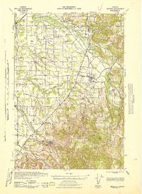
The Molalla River corridor serves as the primary artery for this 1940 tactical survey, illustrating a landscape defined by small agricultural settlements and a maturing timber economy. The transition from the flatlands of Marks Prairie and Gribble Prairie in the west to the rising timbered foothills in the east is punctuated by centers of local life like Scotts Mills and Molalla. For the family historian, the map preserves the locations of numerous rural institutions, from the Miller Cemetery near the southern border to the Trinity Lutheran Church and various one-room schoolhouses like Harmony School and Wildcat School.
Find a feature on this map
58 named features on this map. Tap any name to fly to it.
Don’t see what you’re looking for? This feature index may not catch every label — zoom into the map to look around manually.
Map Details
Editions of this 1940 Molalla Map
2 editions found
Other maps of this area

1911 · Boring
USGS Topo · 1:48,000

1914 · Boring
USGS Topo · 1:62,500

1914 · Oregon City
USGS Topo · 1:62,500

1916 · Tualatin
USGS Topo · 1:62,500

1916 · Estacada
USGS Topo · 1:125,000

1923 · Mount Angel
USGS Topo · 1:62,500

1925 · Stayton
USGS Topo · 1:62,500

1929 · Mill City
USGS Topo · 1:125,000

1939 · Molalla
USGS Topo · 1:62,500

1939 · Oregon City
USGS Topo · 1:62,500