1970s Maps of Treharne, Oregon
Explore 2 historic maps of Treharne from the 1970s. These maps offer a rare glimpse into what life looked like during the 1970s — showing old roads, neighborhoods, homes, and landmarks that have changed or disappeared over time.
Whether you're researching your family's past, planning a metal detecting trip, or studying how Treharne's landscape evolved across the 1970s, these high-resolution maps are a powerful tool for exploring the history of this region.
- Focus on a specific era: All maps on this page are from the 1970s, giving you a focused view of this time period.
- See what’s changed: Compare century-old streets, trails, and buildings to today's modern landscape using overlays and satellite layers.
- Research with precision: Use these maps for genealogy, historical research, land use analysis, or educational projects.
- View, download, or print: Maps are fully viewable online in high resolution, and can be downloaded or printed for your own records.
Start exploring Treharne's history through authentic maps from the 1970s. This is your window into the past.
Treharne, OR maps
(2)- 1979 Map of Vernonia, 1980 Print
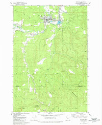 1979 Vernonia1980 Print · USGSColumbia County’s timber country comes into focus in the late seventies, showing the established community of Vernonia along the winding Nehalem River. Genealogists and local historians can trace early family sites like Hoffman Hill or locate the Pioneer Cemetery and Treharne settlement.2 unique versions available
 - 1979 Map of Nehalem River, 1980 Print
 1979 Nehalem River1980 Print · USGSThe northern Oregon coast and its timber-rich interior are captured here in the late seventies, showing the vital connection between sea and forest. Researchers can trace the rail lines of the Southern Pacific and Burlington Northern through historic logging hubs like Vernonia, Timber, and Nehalem.3 unique versions available
End of results
Showing maps 1-2 of 2
Top cities near Treharne
Frequently asked questions
- What are the different types of historical maps available for Treharne?
- What is the oldest map of Treharne?
- Where can I purchase historical maps of Treharne for my home or office?
- Where can I download high-res historical maps of Treharne?
- Are there historical topographic maps available for Treharne?
- Is there historical aerial imagery available for Treharne?
- Where are historical maps of Treharne sourced from?