1940s Maps of McKinley, Oregon
Explore 4 historic maps of McKinley from the 1940s. These maps offer a rare glimpse into what life looked like during the 1940s — showing old roads, neighborhoods, homes, and landmarks that have changed or disappeared over time.
Whether you're researching your family's past, planning a metal detecting trip, or studying how McKinley's landscape evolved across the 1940s, these high-resolution maps are a powerful tool for exploring the history of this region.
- Focus on a specific era: All maps on this page are from the 1940s, giving you a focused view of this time period.
- See what’s changed: Compare century-old streets, trails, and buildings to today's modern landscape using overlays and satellite layers.
- Research with precision: Use these maps for genealogy, historical research, land use analysis, or educational projects.
- View, download, or print: Maps are fully viewable online in high resolution, and can be downloaded or printed for your own records.
Start exploring McKinley's history through authentic maps from the 1940s. This is your window into the past.
McKinley, OR maps
- 1942 Map of Coquille, 1960 Print
 1942 Coquille1960 Print · USGSCoastal Coos County during the early war years reveals a landscape of river-dependent towns and upland coal mines. Genealogists and researchers can trace local landmarks like the County Farm, the Southern Pacific Railroad, and rural schoolhouses including Coaledo Sch and Norway Sch.3 unique versions available
 - 1945 Map of Coquille
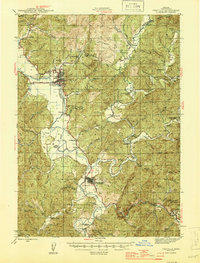 1945 Coquille1945 Print · USGSCoastal Oregon at the height of the war years reveals a landscape defined by the winding Coquille River and a dense network of logging and mining outposts. Researchers can trace the legacy of small-town life through labels like the Overland Coal Mine, the County Farm, and Twin Oaks Sch.
End of results
Showing maps 1-2
Top cities near McKinley
- Coos Bay historical maps
- North Bend historical maps
- Coquille historical maps
- Myrtle Point historical maps
Frequently asked questions
- What are the different types of historical maps available for McKinley?
- What is the oldest map of McKinley?
- Where can I purchase historical maps of McKinley for my home or office?
- Where can I download high-res historical maps of McKinley?
- Are there historical topographic maps available for McKinley?
- Is there historical aerial imagery available for McKinley?
- Where are historical maps of McKinley sourced from?