1900s (20th Century) Maps of Post, Oregon
Explore 7 historic maps of Post from the 1900s (20th Century). These maps offer a rare glimpse into what life looked like during the 1900s — showing old roads, neighborhoods, homes, and landmarks that have changed or disappeared over time.
Whether you're researching your family's past, planning a metal detecting trip, or studying how Post's landscape evolved across the 1900s, these high-resolution maps are a powerful tool for exploring the history of this region.
- Focus on a specific era: All maps on this page are from the 1900s, giving you a focused view of this time period.
- See what’s changed: Compare century-old streets, trails, and buildings to today's modern landscape using overlays and satellite layers.
- Research with precision: Use these maps for genealogy, historical research, land use analysis, or educational projects.
- View, download, or print: Maps are fully viewable online in high resolution, and can be downloaded or printed for your own records.
Start exploring Post's history through authentic maps from the 1900s. This is your window into the past.
Post, OR maps
(7)- 1951 Map of Post, 1953 Print
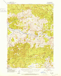 1951 Post1953 Print · USGSCentral Oregon ranching and timber lands are frozen in time during the early fifties as the Crooked River winds through the high country. Researchers can trace the layout of Post, find the old Post School, or locate the Maury Mtn Mines in the southern peaks.3 unique versions available
 - 1955 Map of Bend, 1964 Print
 1955 Bend1964 Print · USGSCentral Oregon was undergoing significant growth in the mid-1960s as irrigation and infrastructure transformed the high desert. Researchers can trace the path of the Oregon Trunk Line, locate old stops like Gateway, and find landmarks like Lava Butte or the Grange.3 unique versions available
 - 1957 Map of Bend
 1957 Bend1957 Print · USGSCentral Oregon in the mid-fifties is a landscape of transition between the high Cascades and the arid volcanic plateau. Local historians can trace the rail corridors of the Oregon Trunk and locate early settlements like Ashwood, Odin Falls, and Camp Sherman.
 - 1958 Map of Bend
 1958 Bend1958 Print · USGSCentral Oregon in the late fifties was a land of high desert ranching and growing mountain towns. Researchers can trace the rail lines of the Oregon Trunk Railroad, find established settlements like Madras and Sisters, or locate landmarks such as Smith Rock and Lava Butte.
 - 1981 Map of Prineville
 1981 Prineville1981 Print · USGSPrineville and the Crooked River valley are seen here in the early eighties as the region balanced timber, ranching, and new water management projects. Genealogists and local historians can trace family-named landmarks like Watkins, locate the Cem, or find old mining sites such as the Amity Mine.
 - 1990 Map of Post
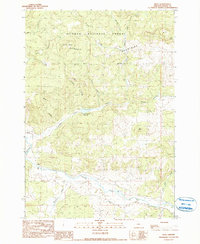 1990 Post1990 Print · USGSThe rural landscape of central Oregon is captured here in the late twentieth century, centered on the Post settlement. Genealogists and researchers can trace family-named landmarks and water sources like Bonnieview Ranch and the Crooked River.
 - 1992 Map of Post, 1997 Print
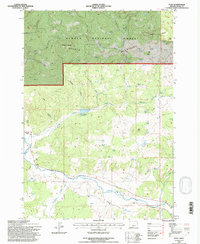 1992 Post1997 Print · USGSThe Crooked River valley comes into sharp focus during the early 1990s as it winds through central Oregon ranching country. Genealogists and historians can trace the foundations of the Post community and find family-named landmarks like Bonnieview Ranch and Joe Butte.
End of results
Showing maps 1-7 of 7
Frequently asked questions
- What are the different types of historical maps available for Post?
- What is the oldest map of Post?
- Where can I purchase historical maps of Post for my home or office?
- Where can I download high-res historical maps of Post?
- Are there historical topographic maps available for Post?
- Is there historical aerial imagery available for Post?
- Where are historical maps of Post sourced from?