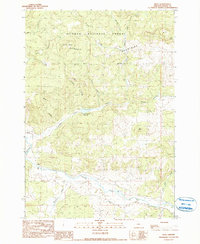
1990 Map of Post
USGS Topo · Published 1990About this map
Post serves as a central focal point in this high-desert landscape of central Oregon, where the winding course of the Crooked River cuts through the terrain. The map details a transition from the structured ranching life at Bonnieview Ranch to the expansive timber and grazing lands of the Ochoco National Forest. Water management is a defining characteristic of the local geography, seen in the presence of Horse Heaven Reservoir and numerous drainages like Pringle Creek and Newsome Creek that feed into the river system.
Find a feature on this map
20 named features on this map. Tap any name to fly to it.
Don’t see what you’re looking for? This feature index may not catch every label — zoom into the map to look around manually.
Map Details
Editions of this 1990 Post Map
This is the sole edition of this map. No revisions or reprints were ever made.
Other maps of this area

1946 · Eagle Rock
USGS Topo · 1:62,500

1948 · Eagle Rock
USGS Topo · 1:62,500

1948 · Ochoco Reservoir
USGS Topo · 1:62,500

1950 · Ochoco Reservoir
USGS Topo · 1:62,500

1951 · Post
USGS Topo · 1:62,500

1951 · Lookout Mtn
USGS Topo · 1:62,500

1955 · Bend
USGS Topo · 1:250,000

1957 · Bend
USGS Topo · 1:250,000

1958 · Bend
USGS Topo · 1:250,000

1981 · Prineville
USGS Topo · 1:100,000