1990s Maps of Bagnell Ferry, Oregon
Explore 2 historic maps of Bagnell Ferry from the 1990s. These maps offer a rare glimpse into what life looked like during the 1990s — showing old roads, neighborhoods, homes, and landmarks that have changed or disappeared over time.
Whether you're researching your family's past, planning a metal detecting trip, or studying how Bagnell Ferry's landscape evolved across the 1990s, these high-resolution maps are a powerful tool for exploring the history of this region.
- Focus on a specific era: All maps on this page are from the 1990s, giving you a focused view of this time period.
- See what’s changed: Compare century-old streets, trails, and buildings to today's modern landscape using overlays and satellite layers.
- Research with precision: Use these maps for genealogy, historical research, land use analysis, or educational projects.
- View, download, or print: Maps are fully viewable online in high resolution, and can be downloaded or printed for your own records.
Start exploring Bagnell Ferry's history through authentic maps from the 1990s. This is your window into the past.
Bagnell Ferry, OR maps
(2)- 1993 Map of Gold Beach
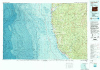 1993 Gold Beach1993 Print · USGSThe Oregon coast at the end of the twentieth century reveals a landscape of river-mouth settlements and deep wilderness. Trace the coastal developments of Gold Beach and Brookings or explore the interior peaks of the Kalmiopsis Wilderness.2 unique versions available
 - 1998 Map of Signal Buttes, 2001 Print
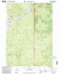 1998 Signal Buttes2001 Print · USGSCoastal Curry County meets the Rogue River in the late nineties, showcasing a landscape of river bars and mountain camps. Genealogists and historians can trace the Jerrys Flat settlement, find the Rumley Cem, and locate the Pickle Ranch (Site).
End of results
Showing maps 1-2 of 2
Top cities near Bagnell Ferry
Frequently asked questions
- What are the different types of historical maps available for Bagnell Ferry?
- What is the oldest map of Bagnell Ferry?
- Where can I purchase historical maps of Bagnell Ferry for my home or office?
- Where can I download high-res historical maps of Bagnell Ferry?
- Are there historical topographic maps available for Bagnell Ferry?
- Is there historical aerial imagery available for Bagnell Ferry?
- Where are historical maps of Bagnell Ferry sourced from?