1960s Maps of Bend, Oregon
Explore 4 historic maps of Bend from the 1960s. These maps offer a rare glimpse into what life looked like during the 1960s — showing old roads, neighborhoods, homes, and landmarks that have changed or disappeared over time.
Whether you're researching your family's past, planning a metal detecting trip, or studying how Bend's landscape evolved across the 1960s, these high-resolution maps are a powerful tool for exploring the history of this region.
- Focus on a specific era: All maps on this page are from the 1960s, giving you a focused view of this time period.
- See what’s changed: Compare century-old streets, trails, and buildings to today's modern landscape using overlays and satellite layers.
- Research with precision: Use these maps for genealogy, historical research, land use analysis, or educational projects.
- View, download, or print: Maps are fully viewable online in high resolution, and can be downloaded or printed for your own records.
Start exploring Bend's history through authentic maps from the 1960s. This is your window into the past.
Bend, OR maps
(4)- 1962 Map of Bend, 1963 Print
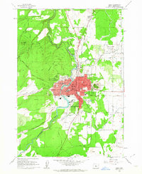 1962 Bend1963 Print · USGSBend and its neighboring volcanic buttes appear in the early sixties as a bustling hub of irrigation, rail, and early high-desert development. Researchers can trace the town's growth through landmarks like Mirror Pond, the Kenwood Sch, and the extensive Central Oregon Canal system.6 unique versions available
 - 1962 Map of Bend Airport, 1963 Print
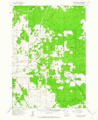 1962 Bend Airport1963 Print · USGSHigh desert agriculture and aviation intersect in Central Oregon during the early sixties. Genealogists and local historians can trace rural school locations like Young Sch, the vital Central Oregon Canal, and the early footprint of the Bend Airport.3 unique versions available
 - 1962 Map of Shevlin Park, 1964 Print
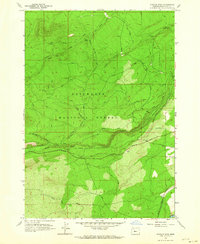 1962 Shevlin Park1964 Print · USGSThe Deschutes National Forest west of Bend is shown here in the early sixties as a hub of timber history and water management. You can trace the Old Railroad Grade, locate the Check Tower, and follow the path of the Tumalo Canal.4 unique versions available
 - 1963 Map of Lava Butte, 1964 Print
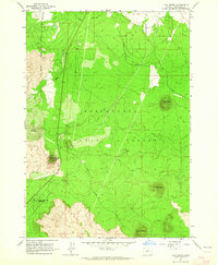 1963 Lava Butte1964 Print · USGSDeschutes County was a landscape of volcanic cones and heavy timber in the early sixties, as shown in this detailed 1963 survey. Researchers can trace the Great Northern railroad and locate local landmarks like the Fire Lookout and Lava River Caves State Park.5 unique versions available
End of results
Showing maps 1-4 of 4
Top cities near Bend
Top neighborhoods of Bend
- Century West historical maps
- Larkspur historical maps
- Southwest Bend historical maps
- Boyd Acres historical maps
- Mountain View historical maps
- River Rim historical maps
See more
Frequently asked questions
- What are the different types of historical maps available for Bend?
- What is the oldest map of Bend?
- Where can I purchase historical maps of Bend for my home or office?
- Where can I download high-res historical maps of Bend?
- Are there historical topographic maps available for Bend?
- Is there historical aerial imagery available for Bend?
- Where are historical maps of Bend sourced from?