1960s Maps of Redmond, Oregon
Explore 3 historic maps of Redmond from the 1960s. These maps offer a rare glimpse into what life looked like during the 1960s — showing old roads, neighborhoods, homes, and landmarks that have changed or disappeared over time.
Whether you're researching your family's past, planning a metal detecting trip, or studying how Redmond's landscape evolved across the 1960s, these high-resolution maps are a powerful tool for exploring the history of this region.
- Focus on a specific era: All maps on this page are from the 1960s, giving you a focused view of this time period.
- See what’s changed: Compare century-old streets, trails, and buildings to today's modern landscape using overlays and satellite layers.
- Research with precision: Use these maps for genealogy, historical research, land use analysis, or educational projects.
- View, download, or print: Maps are fully viewable online in high resolution, and can be downloaded or printed for your own records.
Start exploring Redmond's history through authentic maps from the 1960s. This is your window into the past.
Redmond, OR maps
(3)- 1961 Map of Redmond, 1977 Print
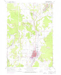 1961 Redmond1977 Print · USGSCentral Oregon's high desert landscape comes into focus at the dawn of the sixties, showcasing the expansion of Redmond and the nearby agricultural hub of Terrebonne. Trace the development of irrigation canals, family-named roads, and rail junctions like Prineville Junction near the banks of the Crooked River.
 - 1962 Map of Forked Horn Butte, 1963 Print
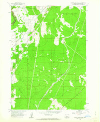 1962 Forked Horn Butte1963 Print · USGSThe high desert landscape outside Redmond comes to life in the early 1960s, showing the intersection of vital irrigation canals and aviation growth. Trace family roots at the Redmond Cem or explore the mid-century footprint of Roberts Field and the Redmond Cave.2 unique versions available
 - 1962 Map of Redmond, 1963 Print
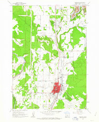 1962 Redmond1963 Print · USGSRedmond and Terrebonne are captured in the early sixties as agricultural and rail hubs. Trace the development of Roberts Field or locate family sites near Redmond Cemetery and Edwin Brown Sch.2 unique versions available
End of results
Showing maps 1-3 of 3
Top cities near Redmond
Frequently asked questions
- What are the different types of historical maps available for Redmond?
- What is the oldest map of Redmond?
- Where can I purchase historical maps of Redmond for my home or office?
- Where can I download high-res historical maps of Redmond?
- Are there historical topographic maps available for Redmond?
- Is there historical aerial imagery available for Redmond?
- Where are historical maps of Redmond sourced from?