1940s Maps of Dads Creek, Oregon
Explore 2 historic maps of Dads Creek from the 1940s. These maps offer a rare glimpse into what life looked like during the 1940s — showing old roads, neighborhoods, homes, and landmarks that have changed or disappeared over time.
Whether you're researching your family's past, planning a metal detecting trip, or studying how Dads Creek's landscape evolved across the 1940s, these high-resolution maps are a powerful tool for exploring the history of this region.
- Focus on a specific era: All maps on this page are from the 1940s, giving you a focused view of this time period.
- See what’s changed: Compare century-old streets, trails, and buildings to today's modern landscape using overlays and satellite layers.
- Research with precision: Use these maps for genealogy, historical research, land use analysis, or educational projects.
- View, download, or print: Maps are fully viewable online in high resolution, and can be downloaded or printed for your own records.
Start exploring Dads Creek's history through authentic maps from the 1940s. This is your window into the past.
Dads Creek, OR maps
(2)- 1946 Map of Dutchman Butte, 1958 Print
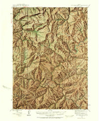 1946 Dutchman Butte1958 Print · USGSThe high timber country of Douglas and Josephine counties is captured here in the mid-1940s during the height of fire-watch forestry. Researchers can trace the early Pacific Trail and locate isolated outposts like the Dutchman Butte Lookout and Bradford Warden Sta.6 unique versions available
 - 1948 Map of Dutchman Butte
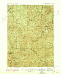 1948 Dutchman Butte1948 Print · USGSThe Oregon backcountry of Douglas and Curry counties is captured here in the late 1940s, showing a landscape of forest management and rail transport. Researchers can locate early fire lookouts and stations like Dutchman Butte Lookout and Bradford Warden Sta alongside the Southern Pacific line.2 unique versions available
End of results
Showing maps 1-2 of 2
Top cities near Dads Creek
Frequently asked questions
- What are the different types of historical maps available for Dads Creek?
- What is the oldest map of Dads Creek?
- Where can I purchase historical maps of Dads Creek for my home or office?
- Where can I download high-res historical maps of Dads Creek?
- Are there historical topographic maps available for Dads Creek?
- Is there historical aerial imagery available for Dads Creek?
- Where are historical maps of Dads Creek sourced from?