1900s (20th Century) Maps of North Fork, Oregon
Explore 7 historic maps of North Fork from the 1900s (20th Century). These maps offer a rare glimpse into what life looked like during the 1900s — showing old roads, neighborhoods, homes, and landmarks that have changed or disappeared over time.
Whether you're researching your family's past, planning a metal detecting trip, or studying how North Fork's landscape evolved across the 1900s, these high-resolution maps are a powerful tool for exploring the history of this region.
- Focus on a specific era: All maps on this page are from the 1900s, giving you a focused view of this time period.
- See what’s changed: Compare century-old streets, trails, and buildings to today's modern landscape using overlays and satellite layers.
- Research with precision: Use these maps for genealogy, historical research, land use analysis, or educational projects.
- View, download, or print: Maps are fully viewable online in high resolution, and can be downloaded or printed for your own records.
Start exploring North Fork's history through authentic maps from the 1900s. This is your window into the past.
North Fork, OR maps
(7)- 1919 Map of Earl
 1919 Earl1919 Print · USGSThe Oregon Coast Range in the years after the Great War shows a landscape of isolated homesteads and river-carved canyons. Researchers can trace early family sites like Fiske Ranch and Stokes Ranch or locate remote rural schoolhouses such as Sulphur Springs School.
 - 1943 Map of Goodwin Peak
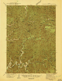 1943 Goodwin Peak1943 Print · USGSCoastal range wilderness and isolated homesteads define this mid-century survey of the Lane and Douglas County line. Genealogists and researchers can locate family-named sites like Townsend Ranch, the North Fork Sch, and landmarks such as Smith River Falls.3 unique versions available
 - 1956 Map of Goodwin Peak, 1958 Print
 1956 Goodwin Peak1958 Print · USGSCoastal Oregon's deep river valleys and high forest ridges are captured here in the mid-fifties, showing the rugged boundary of Lane and Douglas counties. Researchers can locate remote family landmarks like Dailey Ranch, the Smith River Grange, and Sulphur Springs.2 unique versions available
 - 1958 Map of Roseburg, 1960 Print
 1958 Roseburg1960 Print · USGSThe timber valleys and high volcanic peaks of Southern Oregon are captured here in the late fifties. Researchers can trace the Southern Pacific rail line through historic settlements like Cottage Grove, Yoncalla, and Oakridge near the Cascade Range crest.4 unique versions available
 - 1959 Map of Roseburg
 1959 Roseburg1959 Print · USGSThe Umpqua and Willamette valleys meet the high Cascades in this late-fifties study of Southern Oregon's timber and rail corridors. Genealogists and researchers can trace the Southern Pacific RR through historic towns like Roseburg, Yoncalla, and Cottage Grove.
 - 1979 Map of Cottage Grove
 1979 Cottage Grove1979 Print · USGSThe Oregon timber and rail corridors of the late seventies are documented here, centered on the Coast Fork Willamette River and the growing hub of Cottage Grove. Researchers can trace the path of the Southern Pacific railroad as it connects small stations like Divide, Saginaw, and Yoncalla.2 unique versions available
 - 1984 Map of North Fork
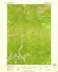
 1984 North Fork1984 Print · USGSCoastal Oregon's timber and river country is captured here in the mid-1980s, centered on the Douglas and Lane County line. Genealogists and local historians can trace family-named landmarks like Noel Ranch, Henderson Peak, and the community hub at the Smith River Grange.
End of results
Showing maps 1-7 of 7
Top cities near North Fork
Frequently asked questions
- What are the different types of historical maps available for North Fork?
- What is the oldest map of North Fork?
- Where can I purchase historical maps of North Fork for my home or office?
- Where can I download high-res historical maps of North Fork?
- Are there historical topographic maps available for North Fork?
- Is there historical aerial imagery available for North Fork?
- Where are historical maps of North Fork sourced from?