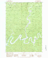
1984 Map of North Fork
USGS Topo · Published 1984About this map
Siuslaw National Forest dominates this section of the Oregon coastal range, where the winding course of the Smith Fork North River carves deep into the timbered landscape. The 1984 survey reveals a small but established community node centered around Noel Ranch and the North Fork settlement, supported by local institutions like the Smith River Grange and the Smith River Marina. These features, along with the Noel Ranch Campground and a nearby Boating Site, indicate an economy and social life tied closely to the river's access and the surrounding forest resources.
Find a feature on this map
43 named features on this map. Tap any name to fly to it.
Don’t see what you’re looking for? This feature index may not catch every label — zoom into the map to look around manually.
Map Details
Editions of this 1984 North Fork Map
This is the sole edition of this map. No revisions or reprints were ever made.
Other maps of this area

1919 · Earl
USGS Topo · 1:48,000

1920 · Siltcoos Lake
USGS Topo · 1:62,500

1923 · Reedsport
USGS Topo · 1:62,500

1941 · Siltcoos Lake
USGS Topo · 1:62,500

1942 · Siltcoos Lake
USGS Topo · 1:62,500

1942 · Reedsport
USGS Topo · 1:62,500

1943 · Goodwin Peak
USGS Topo · 1:62,500

1954 · Coos Bay
USGS Topo · 1:250,000

1955 · Scottsburg
USGS Topo · 1:62,500
1956 · Reedsport
USGS Topo · 1:62,500