1980s Maps of Tiller, Oregon
Explore 2 historic maps of Tiller from the 1980s. These maps offer a rare glimpse into what life looked like during the 1980s — showing old roads, neighborhoods, homes, and landmarks that have changed or disappeared over time.
Whether you're researching your family's past, planning a metal detecting trip, or studying how Tiller's landscape evolved across the 1980s, these high-resolution maps are a powerful tool for exploring the history of this region.
- Focus on a specific era: All maps on this page are from the 1980s, giving you a focused view of this time period.
- See what’s changed: Compare century-old streets, trails, and buildings to today's modern landscape using overlays and satellite layers.
- Research with precision: Use these maps for genealogy, historical research, land use analysis, or educational projects.
- View, download, or print: Maps are fully viewable online in high resolution, and can be downloaded or printed for your own records.
Start exploring Tiller's history through authentic maps from the 1980s. This is your window into the past.
Tiller, OR maps
(2)- 1989 Map of Tiller, 1990 Print
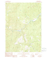 1989 Tiller1990 Print · USGSThe South Umpqua River valley in Douglas County was a landscape of forest management and mountain settlements in the late 1980s. Researchers can locate remote landmarks like the Rainville Cemetery, Graham Placer Mines, and the Drew School.
 - 1989 Map of Crater Lake, 1990 Print
 1989 Crater Lake1990 Print · USGSJackson County and the High Cascades are captured in the late eighties, showing a landscape shaped by vast national forests and the deep waters of Crater Lake. You can trace rural life near Prospect and Butte Falls or locate landmarks like the Cinnabar Mine and Wizard Island.
End of results
Showing maps 1-2 of 2
Frequently asked questions
- What are the different types of historical maps available for Tiller?
- What is the oldest map of Tiller?
- Where can I purchase historical maps of Tiller for my home or office?
- Where can I download high-res historical maps of Tiller?
- Are there historical topographic maps available for Tiller?
- Is there historical aerial imagery available for Tiller?
- Where are historical maps of Tiller sourced from?