1940s Maps of John Day, Oregon
Explore 2 historic maps of John Day from the 1940s. These maps offer a rare glimpse into what life looked like during the 1940s — showing old roads, neighborhoods, homes, and landmarks that have changed or disappeared over time.
Whether you're researching your family's past, planning a metal detecting trip, or studying how John Day's landscape evolved across the 1940s, these high-resolution maps are a powerful tool for exploring the history of this region.
- Focus on a specific era: All maps on this page are from the 1940s, giving you a focused view of this time period.
- See what’s changed: Compare century-old streets, trails, and buildings to today's modern landscape using overlays and satellite layers.
- Research with precision: Use these maps for genealogy, historical research, land use analysis, or educational projects.
- View, download, or print: Maps are fully viewable online in high resolution, and can be downloaded or printed for your own records.
Start exploring John Day's history through authentic maps from the 1940s. This is your window into the past.
John Day, OR maps
(2)- 1940 Map of John Day, 1960 Print
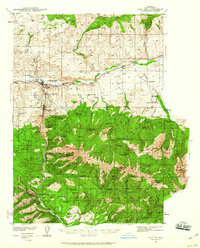 1940 John Day1960 Print · USGSGrant County is captured here at the end of the 1930s as a region defined by high-desert ranching and the remnants of a gold-mining boom. Genealogists can trace early landmarks like Canyon City, the Joaquin Miller Resort, and several abandoned workings such as the Iron King Mine.2 unique versions available
 - 1943 Map of John Day
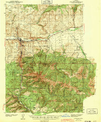 1943 John Day1943 Print · USGSGrant County is captured during the early 1940s, showing the intersection of ranching and the waning mining era near Canyon City. Genealogists and historians can locate family landmarks like the Kuhl Ranch or trace the history of the Golden West Mine (abandoned) and Marysville Sch.2 unique versions available
End of results
Showing maps 1-2 of 2
Top cities near John Day
Frequently asked questions
- What are the different types of historical maps available for John Day?
- What is the oldest map of John Day?
- Where can I purchase historical maps of John Day for my home or office?
- Where can I download high-res historical maps of John Day?
- Are there historical topographic maps available for John Day?
- Is there historical aerial imagery available for John Day?
- Where are historical maps of John Day sourced from?