1970s Maps of John Day, Oregon
Explore 2 historic maps of John Day from the 1970s. These maps offer a rare glimpse into what life looked like during the 1970s — showing old roads, neighborhoods, homes, and landmarks that have changed or disappeared over time.
Whether you're researching your family's past, planning a metal detecting trip, or studying how John Day's landscape evolved across the 1970s, these high-resolution maps are a powerful tool for exploring the history of this region.
- Focus on a specific era: All maps on this page are from the 1970s, giving you a focused view of this time period.
- See what’s changed: Compare century-old streets, trails, and buildings to today's modern landscape using overlays and satellite layers.
- Research with precision: Use these maps for genealogy, historical research, land use analysis, or educational projects.
- View, download, or print: Maps are fully viewable online in high resolution, and can be downloaded or printed for your own records.
Start exploring John Day's history through authentic maps from the 1970s. This is your window into the past.
John Day, OR maps
(2)- 1972 Map of John Day, 1976 Print
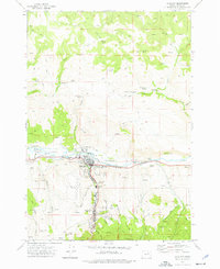 1972 John Day1976 Print · USGSGrant County in the early seventies shows a landscape where industrial gold mining and civic growth meet. Genealogists and historians can trace the foundations of John Day, locate the historic Boot Hill Cem, and explore vast Dredge Tailings along the river.2 unique versions available
 - 1978 Map of John Day, 1997 Print
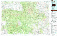 1978 John Day1997 Print · USGSEastern Oregon in the late 1970s shows a landscape defined by timber, mining, and high-desert hydrology. Researchers can trace the legacy of the Standard Mine, the route of the Oregon and Northwestern Railroad, and the remote outposts of Seneca and Prairie City.2 unique versions available
End of results
Showing maps 1-2 of 2
Top cities near John Day
Frequently asked questions
- What are the different types of historical maps available for John Day?
- What is the oldest map of John Day?
- Where can I purchase historical maps of John Day for my home or office?
- Where can I download high-res historical maps of John Day?
- Are there historical topographic maps available for John Day?
- Is there historical aerial imagery available for John Day?
- Where are historical maps of John Day sourced from?