
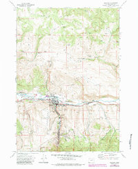
1972 Map of John Day
USGS Topo · Published 1976About this map
John Day and Canyon City anchor this 1970s survey of central Grant County, revealing a landscape deeply marked by its mining heritage. The valley floor along the John Day River is dominated by extensive Dredge Tailings, evidence of industrial-scale gold recovery that reshaped the river's course. To the south, the historical significance of the area is further evidenced by the Old Humboldt Diggings and Marysville Placer, alongside smaller operations like the Potato Patch Mine.
Find a feature on this map
54 named features on this map. Tap any name to fly to it.
Don’t see what you’re looking for? This feature index may not catch every label — zoom into the map to look around manually.
Map Details
Editions of this 1972 John Day Map
2 editions found
Other maps of this area

1940 · Mount Vernon
USGS Topo · 1:62,500

1940 · John Day
USGS Topo · 1:62,500

1943 · John Day
USGS Topo · 1:62,500

1943 · Mount Vernon
USGS Topo · 1:62,500

1949 · Long Creek
USGS Topo · 1:62,500

1949 · Susanville
USGS Topo · 1:62,500

1951 · Susanville
USGS Topo · 1:62,500

1951 · Long Creek
USGS Topo · 1:62,500

1955 · Canyon City
USGS Topo · 1:250,000

1959 · Canyon City
USGS Topo · 1:250,000