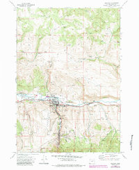
1972 Map of John Day
USGS Topo · Published 1984About this map
The John Day River valley dominates this map, showing the area as it appeared in the early 1970s. The landscape around John Day and Canyon City reveals a heavy industrial history, particularly the extensive Dredge Tailings that line the riverbanks, left behind by massive gold dredging operations. This topographical survey preserves the footprint of resource extraction alongside civic life, featuring the Old Humboldt Diggings and Potato Patch Mine tucked into the southern gulches. Local history researchers will find several notable burial sites including Boot Hill Cem, Rest Lawn Cem, and St Andrews Cem. Transportation and entertainment landmarks of the era are also present, such as the John Day State Airport and a Drive-in Theater west of town. The transition from the river valley into the surrounding timbered heights is marked by numerous natural water sources like Davis Creek Springs and Big Springs, illustrating the vital water network that supported both mining and settlement.
Find a feature on this map
54 named features on this map. Tap any name to fly to it.
Don’t see what you’re looking for? This feature index may not catch every label — zoom into the map to look around manually.
Map Details
Editions of this 1972 John Day Map
2 editions found

Other maps of this area

1940 · Mount Vernon
USGS Topo · 1:62,500

1940 · John Day
USGS Topo · 1:62,500

1943 · John Day
USGS Topo · 1:62,500

1943 · Mount Vernon
USGS Topo · 1:62,500

1949 · Long Creek
USGS Topo · 1:62,500

1949 · Susanville
USGS Topo · 1:62,500

1951 · Susanville
USGS Topo · 1:62,500

1951 · Long Creek
USGS Topo · 1:62,500

1955 · Canyon City
USGS Topo · 1:250,000

1959 · Canyon City
USGS Topo · 1:250,000