1900s (20th Century) Maps of Venator, Oregon
Explore 6 historic maps of Venator from the 1900s (20th Century). These maps offer a rare glimpse into what life looked like during the 1900s — showing old roads, neighborhoods, homes, and landmarks that have changed or disappeared over time.
Whether you're researching your family's past, planning a metal detecting trip, or studying how Venator's landscape evolved across the 1900s, these high-resolution maps are a powerful tool for exploring the history of this region.
- Focus on a specific era: All maps on this page are from the 1900s, giving you a focused view of this time period.
- See what’s changed: Compare century-old streets, trails, and buildings to today's modern landscape using overlays and satellite layers.
- Research with precision: Use these maps for genealogy, historical research, land use analysis, or educational projects.
- View, download, or print: Maps are fully viewable online in high resolution, and can be downloaded or printed for your own records.
Start exploring Venator's history through authentic maps from the 1900s. This is your window into the past.
Venator, OR maps
(6)- 1955 Map of Burns, 1964 Print
 1955 Burns1964 Print · USGSHarney County's high desert ranching and timber heartland is captured here in the mid-fifties, centered on the hub of Burns and Hines. Genealogists and researchers can locate remote landmarks like the Suntex School, New Princeton P. O., and the Lumber Mill.3 unique versions available
 - 1958 Map of Burns
 1958 Burns1958 Print · USGSHarney County ranching and timber lands are captured here in the late fifties. Genealogists and local historians can trace family holdings and rural institutions, from the Kimball Flat School to remote outposts like Crow Camp Ranch and the Sutton Ranch.
 - 1959 Map of Burns
 1959 Burns1959 Print · USGSHarney County in the late fifties remains a landscape of high-desert ranching and timber production, centered on the hubs of Burns and Hines. Researchers can locate remote rural institutions like the Suntex School or trace family landholdings such as the Stallard Ranch and O'Keefe Homestead.
 - 1968 Map of Venator, 1972 Print
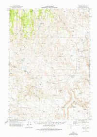 1968 Venator1972 Print · USGSHarney County's high desert ranching country comes into focus in the early seventies, detailing a landscape of isolated homesteads and vital waterholes. Genealogists and historians can trace the bounds of Venator, Dunnean, and family-named landmarks like Hunter Ranch.
 - 1972 Map of Venator, 1977 Print
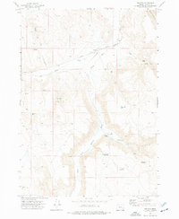 1972 Venator1977 Print · USGSHarney County ranchlands and the high desert interior are captured here during the early 1970s, showing the intersection of rail and river. You can trace the Union Pacific line as it follows the South Fork Malheur River past Venator and Hughes Ranch.
 - 1978 Map of Malheur Lake, 1997 Print
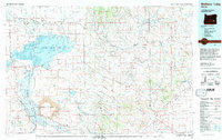 1978 Malheur Lake1997 Print · USGSThe Harney Basin in the late seventies reveals a land of vast wetlands and volcanic remnants. Researchers can trace isolated outposts like New Princeton and Venator or the unique geological formations of Diamond Craters.
End of results
Showing maps 1-6 of 6
Frequently asked questions
- What are the different types of historical maps available for Venator?
- What is the oldest map of Venator?
- Where can I purchase historical maps of Venator for my home or office?
- Where can I download high-res historical maps of Venator?
- Are there historical topographic maps available for Venator?
- Is there historical aerial imagery available for Venator?
- Where are historical maps of Venator sourced from?