1990s Maps of Madras, Oregon
Explore 4 historic maps of Madras from the 1990s. These maps offer a rare glimpse into what life looked like during the 1990s — showing old roads, neighborhoods, homes, and landmarks that have changed or disappeared over time.
Whether you're researching your family's past, planning a metal detecting trip, or studying how Madras's landscape evolved across the 1990s, these high-resolution maps are a powerful tool for exploring the history of this region.
- Focus on a specific era: All maps on this page are from the 1990s, giving you a focused view of this time period.
- See what’s changed: Compare century-old streets, trails, and buildings to today's modern landscape using overlays and satellite layers.
- Research with precision: Use these maps for genealogy, historical research, land use analysis, or educational projects.
- View, download, or print: Maps are fully viewable online in high resolution, and can be downloaded or printed for your own records.
Start exploring Madras's history through authentic maps from the 1990s. This is your window into the past.
Madras, OR maps
(4)- 1992 Map of Madras West, 1997 Print
 1992 Madras West1997 Print · USGSThe Agency Plains and the Deschutes River canyon come into sharp focus in the early 1990s as Jefferson County's agricultural and energy sectors evolved. Researchers can trace irrigation networks like the North Unit Main Canal or locate the Vanora (Site) and Milo Gardi Cem.
 - 1992 Map of Buck Butte, 1997 Print
 1992 Buck Butte1997 Print · USGSJefferson County’s high desert ranching country is captured here during the 1990s, where public grasslands meet private homesteads. Trace historic water rights and cattle operations through features like Willow Creek Corral, Dayton Grant Well, and the Bennett Weir.
 - 1992 Map of Madras East, 1997 Print
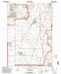
 1992 Madras East1997 Print · USGSJefferson County’s high desert plateau and canyonlands come into focus in the early nineties, showing a landscape defined by agriculture and protected grasslands. Researchers can trace family-named sites like Monner Spring, the town of Paxton, and the steep terrain of Old Maids Canyon.
 - 1992 Map of Culver, 1998 Print
 1992 Culver1998 Print · USGSMadras and the surrounding Jefferson County landscape appear here in the early nineties, centered on the region's vital irrigation networks and agricultural development. Researchers can trace the path of numerous siphons and canals serving the area near Madras.
End of results
Showing maps 1-4 of 4
Top cities near Madras
Frequently asked questions
- What are the different types of historical maps available for Madras?
- What is the oldest map of Madras?
- Where can I purchase historical maps of Madras for my home or office?
- Where can I download high-res historical maps of Madras?
- Are there historical topographic maps available for Madras?
- Is there historical aerial imagery available for Madras?
- Where are historical maps of Madras sourced from?