1960s Maps of Madras, Oregon
Explore 4 historic maps of Madras from the 1960s. These maps offer a rare glimpse into what life looked like during the 1960s — showing old roads, neighborhoods, homes, and landmarks that have changed or disappeared over time.
Whether you're researching your family's past, planning a metal detecting trip, or studying how Madras's landscape evolved across the 1960s, these high-resolution maps are a powerful tool for exploring the history of this region.
- Focus on a specific era: All maps on this page are from the 1960s, giving you a focused view of this time period.
- See what’s changed: Compare century-old streets, trails, and buildings to today's modern landscape using overlays and satellite layers.
- Research with precision: Use these maps for genealogy, historical research, land use analysis, or educational projects.
- View, download, or print: Maps are fully viewable online in high resolution, and can be downloaded or printed for your own records.
Start exploring Madras's history through authentic maps from the 1960s. This is your window into the past.
Madras, OR maps
(4)- 1963 Map of Culver, 1964 Print
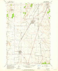 1963 Culver1964 Print · USGSJefferson County farming and rail life are centered here in the early sixties. Researchers can trace ancestral roots at the German Cemetery, locate the old railroad line, and find local landmarks like the Drive-in Theater near Madras.
 - 1963 Map of Madras West, 1964 Print
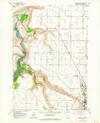 1963 Madras West1964 Print · USGSJefferson County in the early 1960s shows a landscape of dramatic river canyons and irrigation expansion. Trace family history at the Milo Gard Cem or explore the rail line at Madras Sta and the massive Pelton Dam.3 unique versions available
 - 1963 Map of Madras East, 1964 Print
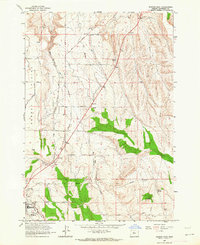 1963 Madras East1964 Print · USGSJefferson County in the early 1960s reveals a transition from open range to organized agriculture and transit. Genealogists and local historians can trace family-named sites like Schmoker Spring and Kutcher Well or the rail path of the Oregon Trunk.2 unique versions available
 - 1963 Map of Buck Butte, 1964 Print
 1963 Buck Butte1964 Print · USGSJefferson County ranching life is well-documented in the early sixties, showing a landscape defined by water rights and remote outposts. Genealogists and local historians can trace family-named sites like Dayton-Grant Well and Boyce Corral near the heights of Buck Butte.
End of results
Showing maps 1-4 of 4
Top cities near Madras
Frequently asked questions
- What are the different types of historical maps available for Madras?
- What is the oldest map of Madras?
- Where can I purchase historical maps of Madras for my home or office?
- Where can I download high-res historical maps of Madras?
- Are there historical topographic maps available for Madras?
- Is there historical aerial imagery available for Madras?
- Where are historical maps of Madras sourced from?